They Went Without Me so I'll Go Without Them

4x4x4doors

Explorer
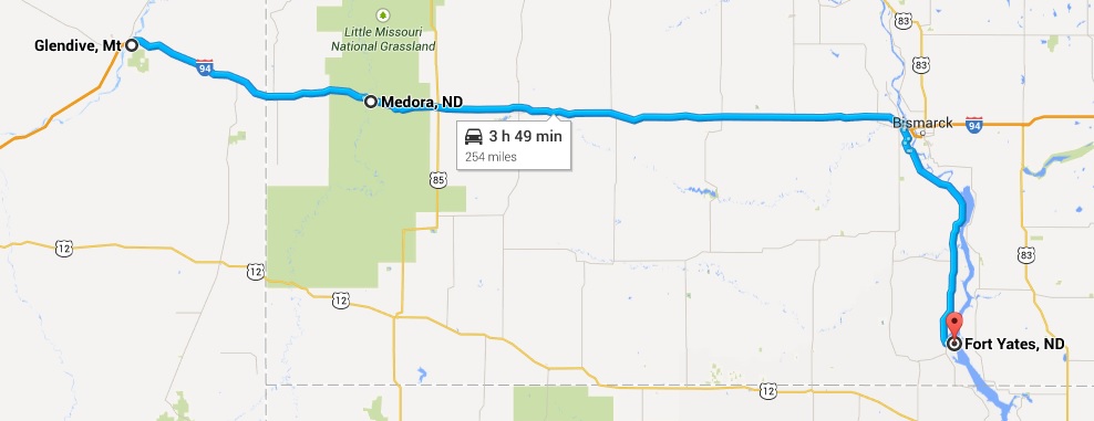
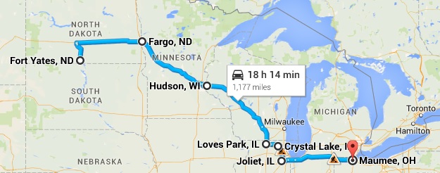
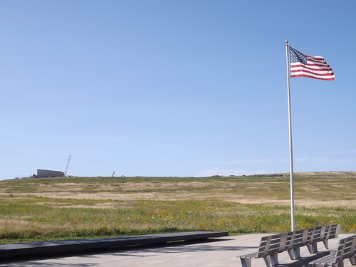
US Border to Butte, Montana

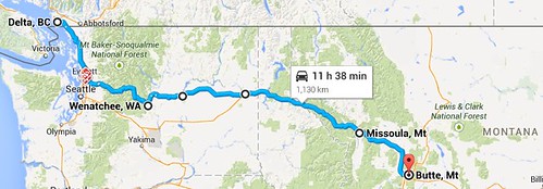
amapborder_butte by RKHolman, on Flickr
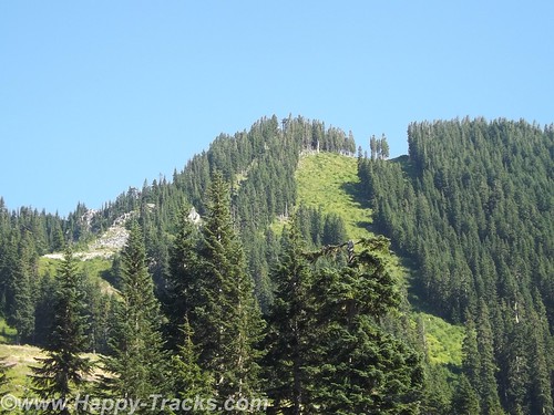
We started heading southeast from Everett and into Mt. Baker-Snoqualmie National Forest and eventually climbing up to Stevens Pass. There was a ski lodge resort there that appeared to be open all year, even when there was no snow, but it had closed for the day before we arrived and took a break in their parking lots. We saw bicyclists coming up and over from the east side. I admire their stamina and determination but didn’t share their interest in bicycling the area.
DSCF8623 by RKHolman, on Flickr
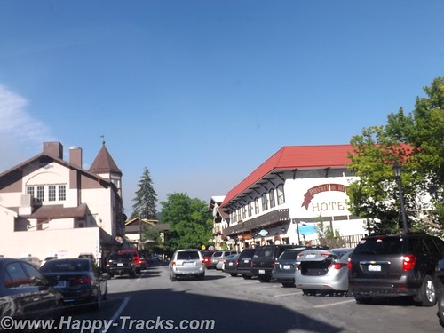
As we started down the east side of the pass, we were starting to see smoke from wildfires but didn’t know exactly where they were. As we exited the National Forest, we entered Leavenworth, a small Alpine town like several in the area. A tourist town, maybe winter ski area but busy as we drove through.
DSCF8629 by RKHolman, on Flickr
DSCF8638 by RKHolman, on Flickr
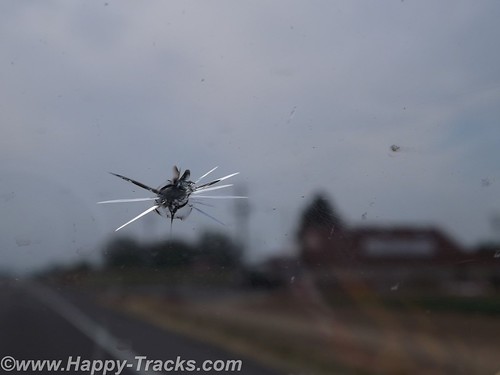
On new pavement, we were passed by a truck headed west and managed to catch a rock from him with our windshield. After the warnings of rocky roads and potential damage in Canada and Alaska, it was somewhat ironic that we did get the crack on fresh smooth pavement in Washington.
We drove on to Wenatchee and stopped for the night in the first place we found available, Inn at the River. The smoke was now very noticeable and it was hot as it would be for the next couple of days. We crossed the river to find our lodging but it took a bit to find the river from the inn as it was on the other side of the freeway and the railroad tracks. We overheard someone at the desk talking about having to be careful in choosing route to Seattle due to the fires and the smoke. Many of the hotel guests were firefighters.
Inn at the River sits across the street from Valley Mall. We went in to replenish the vitamin supply at a GNC store and then had dinner at Shari’s Restaurant and Pies. Shari’s is a chain similar in concept to Denny’s, Perkins, etc. We had eaten one in Bangor for the sub reunion as it was across the street from the hotel where we stayed there. The food was good and the pastry looked tempting but we passed.
We continued east towards Spokane through miles and miles of relatively flat land given to orchard agriculture. Through much of the area, the crops were identified by signs alongside the road. It helped us see the variety of crops and helped with the “What’s that?” questions that always seem to arise as we go through farm country.
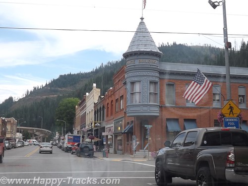
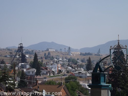
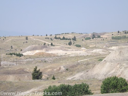
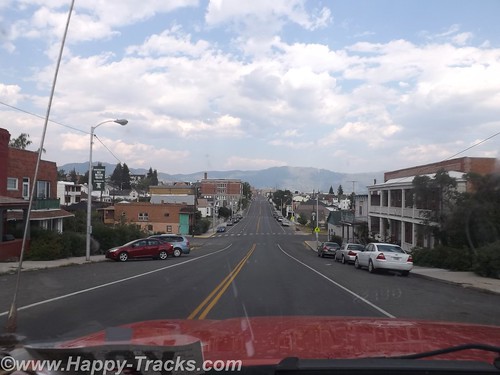
We dropped down and picked up Interstate 90 into Idaho and stopped for lunch in Wallace. Wallace is in a pass with mountains on both sides with the interstate highway squeezing through. Wallace turned out to be about 4 blocks wide, all on the same side of the interstate.

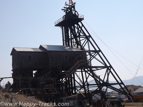
Wallace had been a silver mining town and the restaurant where we stopped for lunch had a gift shop with silver jewelry on display. The restaurant was pretty quiet with the hostess/waitress/cook all being the same person.
DSCF8647 by RKHolman, on Flickr
There was an accordion festival scheduled for the coming weekend. Wallace also has a brothel museum but we didn’t find out about it until after we had already left. There were numerous references to bicycle races as Wallace is a major stop on several annual cross-country races.
More at this link
 

4x4x4doors

Explorer
Butte, Montana
World Museum of Mining, Copper King Mansion, Dumas Brothel, Our Lady of the Rockies
Butte, Montana is a city of about 35,000 these days and is the fifth largest city in Montana. Its history revolves around the mining industry and was a boomtown during the early 20th century with all the stages of development from camp, to boomtown and mature city. It shifted to a town of historic preservation and environmental cleanup. Butte is unlike other mining towns in that the mining operations are woven within the fabric of the city itself.
DSCF8905 by RKHolman, on Flickr
We arrived from Missoula and stopped on the west side of town for fuel. We knew we wanted to see the Mining Museum so we spun the GPS roulette wheel and decided to take a ride by to see if they were still open. I call it the GPS roulette wheel because sometimes the route the GPS gives may not be that workable. In this particular case, it routed us via Bluebird Trail, or the back way, into the World Museum of Mining. A bluebird could follow the trail easily but it was a bit rugged for us, just a dirt road with deep ruts that wandered up and down a few low hills past some unused equipment and a dog that seemed interested in chasing the interlopers away.
DSCF8881 by RKHolman, on Flickr
The road had cross ruts and was among the worst roads of the entire trip. It did lead us up to the paved parking lot of the World Museum of Mining’s paved parking lot (which was closed for the day) and onto the city streets of the Montana Tech of the University of Montana campus and thus into downtown Butte.
DSCF8735 by RKHolman, on Flickr
We found and checked into our motel for the night. As we had seen in several other places, some of our fellow guests were motorcyclists which made for an interesting show the next morning as we sat eating the complimentary breakfast. They were loading up and carrying a fair amount of luggage with them. Each piece had a particular place and set of tie-downs leading to an interesting game of 3D Tetris as they loaded up. One of our fellow diners was also taken by the show and remarked how she used to ride a scooter to the market and had her own adventures tying down a watermelon. She also shared that she was a widow who had learned the value of duct tape for a myriad of uses after her husband’s passing.
DSCF8897 by RKHolman, on Flickr
We left and headed back to the World Museum of Mining (using the smoother paved way through town).
As usual, more to be found here.
 

4x4x4doors

Explorer
Hardin to Glendive MT via Little Big Horn
View attachment 241879
Interesting piece of machinery we passed on the railroad. 1 of about 6 total just tooling on by
View attachment 241880
Just a sample of the terrain and the info signs at Little Big Horn
View attachment 241881
Just a sample of the terrain and the info signs at Little Big Horn
View attachment 241882
Memorial to the soldiers on top of Last Stand Hill (bodies buried beneath it)
View attachment 241883
Memorial to the Indians next to top of Last Stand Hill. Generally the Indians took their dead elsewhere. (Note the term Indian. Its used a lot out here rather than the terms we are being told are more sensitive - no offense intended)
View attachment 241884
Ranger Interpreter Adelson gave quite an animated presentation of the battle. His presentation was interesting in part because of the attitude towards Custer. It spoke of Custer's past successes in the Civil War against tall odds and perhaps that Custer's luck had run out rather than being the arrogant so and so we so often hear about. Just a different perspective.
View attachment 241885
Veterans Cemetery on the National Monument grounds. These veterans are from later wars. They stopped accepting new internees in 1978 due to space constraints.
View attachment 241886
Some of the changing scenery between Little Big Horn and Glendive
View attachment 241887
Some of the changing scenery between Little Big Horn and Glendive

Blog post is here
 

4x4x4doors

Explorer
ND Badlands and Teddy Roosevelt NP
A young and skinny Theodore Roosevelt, Jr. made his way to the North Dakota from New York in 1883 to hunt bison. His time and experiences there shaped his perspective and the national conservation policy for decades to come. He was traveling to a place where he was an unknown and would not likely be warmly welcomed as he was an outsider, an Easterner and a “city slicker” to boot.
DSCF9067 by RKHolman, on Flickr
During his hunting trip, he expressed an interest in cattle ranching and eventually made an investment in that endeavor. In that year, the men who tended the cattle investment also built the Maltese Cross Cabin. Roosevelt’s investment of $14,000 (more than his annual salary at the time) was seen as an admission ticket to a different way of life in the wide open spaces. Dakota-grown cattle were seen as a solid investment partly because of the variety of grazing foods available and also because of the efforts of the Marquis de Morès to establish a meat packing industry to packing the meat in the Dakota territory and ship the meat in refrigerated rail cars to the markets in the east.
DSCF9122 by RKHolman, on Flickr
DSCF9025 by RKHolman, on Flickr
Roosevelt suffered double personal tragedies in February of 1884 when both his mother and his wife died the same day. The tragedy struck him hard (as to be expected) and he returned to his Dakota cabin for a period of mourning and introspection. He wrote a book about his hunting exploits and becoming a cattleman and expanded his holdings. He threw himself into his cattle raising business, becoming president of the Cattleman’s Association and stepping out to make peace with his neighbor, the Marquis, who was in jail on charges of murder. He also expanded his land holdings to include the Elkhorn Ranch.
Despite his personal warnings about overgrazing the territory, he also expanded his herds. In 1885, thieves stole his boat and he gave chase with two others eventually capturing the thieves downriver. He chose to walk the thieves back to authorities in Dickinson. The story is told in some places that he did so for the reward money or that he did so because they deserved a trial. In either event, his multiday walk to Dickinson with the perpetrators added to his reputation and helped dispel the view that he was a soft Easterner.
The seasons of 1886-1887 would prove disastrous to the cattle industry in Medora and eventually the town itself. The summer was brutally hot and dry with temperatures reaching 125F. Then after the grasses had been so devastated by the heat, the winter was equally extreme with temperatures as low as -41F. The cattle starved or froze that winter.
Although Roosevelt had been hit hard financially, he had grown tremendously in the eyes of the locals and eventually the nation. His embrace of the cowboy life contributed to his formation of the Rough Riders which brought him fame during the Spanish-American War and his experiences with the cattle contributed to his beliefs in conservation and management of our natural resources which carried into his Presidency. Although he would not return often or for long periods after 1887, the experiences shaped his actions later.
DSCF9123 by RKHolman, on Flickr
During Roosevelt’s presidency, the Maltese Cross cabin was exhibited at the World’s Fair in St. Louis, MO and at the Lewis and Clark Centennial Exposition in Portland, OR. Later it was moved to the state fairgrounds in Fargo, ND and then eventually to the state capitol grounds in Bismarck where it remained for 50 years. In 1959, the cabin was relocated to its present site and renovated. The most recent preservation work occurred in 2000.
Fellow travelers onboard the SS Matanuska, the ferry we rode along the Inland Passage recommended that we include the North Dakota Badlands as part of our journey east as they are indeed different than the South Dakota Badlands.
glendive2ftyates_map.jpg

Theodore Roosevelt National Park is really three geographically separated areas of badlands in western North Dakota. The park covers 110 square miles of land in three sections: the North Unit, the South Unit, and the Elkhorn Ranch Unit.

Click for more
 

4x4x4doors

Explorer
Prairie Knights, Ft. Yates, On-A-Slant Mandan Village

We left Medora and headed east on I-94 towards the Missouri River and Bismarck. We called a couple of hotels but found no rooms available without a reservation. Someone recommended the Prairie Knights Resort. Since it was about 50 miles off the highway, we called ahead to check on room availability. They told us they had plenty of rooms so there was no need to make a reservation. Mmmmmkay?
DSCF9140 by RKHolman, on Flickr
We drove south with the Missouri River to our left through a couple of very small settlements and passed the Ft. Lincoln State Park entrance. It really is 50 miles and there is virtually nothing until you reach the Prairie Knights Casino and Resort. Prairie Knights is a casino and lodge located on the Standing Rock Indian Reservation. It is operated by the Standing Rock Indian Tribe. The casino offers high stakes gaming options, along with 725 slot machines, blackjack, craps, among other games. The lodge portion of the casino consists of 200 guest rooms.
Once we finally get there, we see that they have a landing on the River, the lodge, a restaurant (buffet style), the casino and a small gas station with prices comparable to what we'd seen in Bismarck.
DSCF9143 by RKHolman, on Flickr
When we go to check in, the clerk asked if we were members of the Prairie Club. Uh, no. Before we get registered, they suggest we go into the casino and register. The registration is free but it knocks $25 off our room rate and gives us $10 to spend in the casino. We are now Prairie club members! We walk around a bit, get some dinner at the buffet and call it a night.
The next morning we head back north towards Mandan and the Ft. Lincoln State Park. Although we didn't use them, it should be noted that the park has primitive and developed campgrounds and rental cabins near the riverbank. We didn't go to those areas of the park to check them out. There are also hiking and biking trails.
The visitor center building contains a display that includes exhibits from the Lewis and Clark expedition and from the Mandan Indians who had a village there.
DSCF9156 by RKHolman, on Flickr
This is where the tour starts for the On-A-Slant Mandan Indian Village. Parts of the village have been the subject of archaeological research and some restoration. Their society was matriarchal with families dwelling in the same lodge including daughters and sons-in-law. The lodge would pass to the eldest daughter on the death of her mother.
The lodges were circular with a fire pit in the center, venting through a hole in the roof which could be covered in hides in times of bad weather. The lodges were also built into the earth with dirt and grass on the outside and over the roof which provided insulation from the temperature extremes. The guide told us of the lodges maintaining 60 degrees even in the coldest parts of winter and they were cool on this hot day when we visited. Generally, the lodge was entered from the side with a partition wall separating the entrance from the main room for weather and defenses. Sleeping pads were around the circumference.
DSCF9155 by RKHolman, on Flickr
The Mandans were stationary people with language similar to the Sioux. They grew crops and hunted animals while trading with the nomadic tribes. A typical Mandan village consisted of 12 to 100 of these dome-shaped lodges. Their oral traditions indicated they had once occupied the eastern North America.
Their villages were often stockaded for protection and they hosted many of the European explorers, including the Lewis and Clark Expedition and Prussian scientist Prince Maximillian.
ftyates_maumee.jpg

Click here for more
 

RangerRocket

Observer
Small world. I work in Maumee (pronounced 'Maw Mee'), a suburb of Toledo for Dana Corporation. Unicat TC54 parked is parked in my driveway.
 

4x4x4doors

Explorer
Flight 93 Memorial and Home Again, Wrap Up

We are often given to rushing the last part of the trip wherever we go. A trip to visit family In Florida will sometimes turn into a marathon one day ride home. A trip to the beach will find us looking at each other late in the evening and saying “let’s just go on home” and arriving at midnight. Aware of this tendency, we tried not to do it this time. One consequence of that behavior is that we often don’t visit the places closer to home while telling ourselves we’ll visit as a day trip from home and then keep putting it off until later.
DSCF9218 by RKHolman, on Flickr
This time, prompted by pictures shared by our friend Tra Maslar, we stopped instead of driving past the Flight 93 Memorial in Stony Creek township, 2 miles north of Shanksville PA. We stopped for lunch in Shanksville and then followed the signs to the Memorial.
DSCF9213 by RKHolman, on Flickr
Being recent history, most of us remember where we were and what we were doing when Flight 93 crashed on September 11, 2001. Briefly, of the four aircraft hijacked by terrorists on September 11, Flight 93 is the only one that did not reach its intended target, presumed to be the US Capitol building in Washington, DC. Several passengers and crew members made telephone calls aboard the flight and learned about the attacks on the World Trade Center and the Pentagon. The passengers decided to mount an assault against the hijackers and wrest control of the aircraft to prevent it reaching its target. While successful, all 44 people onboard (including the four hijackers) died in the process.
DSCF9215 by RKHolman, on Flickr
We have visited the memorials at WTC and Pentagon sites. Flight 93 crashed in a field in the countryside. The memorial itself is predominantly built but the supporting structures (visitor center and grounds) are still under construction. Since our visit, a fire at the NPS administration building has destroyed the flag that flew over the Capitol that day but most of the remainder of the memorial collection is safe.
DSCF9217 by RKHolman, on Flickr
Each of the 40 heroes are named on one of the white stones at the right above. Looking at the site from this vantage point, you are looking along the path the airplane took as it crashed and went along the ground, stopping near the boulder shown in the picture below.
DSCF9221 by RKHolman, on Flickr
DSCF9222 by RKHolman, on Flickr
Although it’s been 13 years, the memorial still tugs at some tender spots and memories of that awful day. The memorial is a fitting tribute to those 40 brave men and women who sacrificed themselves for others.
OH2MD_map.jpg

Blog post here, includes some overall thoughts on the trip.
 

profdlp

Adventurer
Nicely put. I intend to visit that site myself at some point. Like you mentioned, I always seem to be on my way to somewhere else and in a hurry when I am nearby.
 

4x4x4doors

Explorer
Yes. We trekked by it several times a year for 3.5 years when the daughter was in school in Ohio but it was always "We need to do that sometime". Definitely worth the stop.

To all who have commented and haven't received a response, thanks for the feedback. I was reading your posts but not necessarily replying.
 

4x4x4doors

Explorer
Just an FYI. the stadium was built in 1981. the roof was rebuilt for the 2010 olympics :) its where our football team plays and our soccer team.

great pics!! loving the journey.

Thanks for the clarification. Mrs and I were talking that we're learning more about where we were in posting the blog. :coffeedrink:
 

ALC

New member
Great write up of your trip. I just read your expanded narrative. Thank you for taking the time to fill us in with more details. The photos were excellent.
 

Forum statistics

Threads
185,783
Messages
2,878,183
Members
225,329
Latest member
FranklinDufresne

Members online

Top