Brisbane to Tasmania and back again....an Australian 7 week adventure

1leglance

2007 Expedition Trophy Champion, Overland Certifie
Too funny Mal....I was wondering why I was enjoying your trip report so much.....actually didn't realize it was YOU :)
Guess I should have looked closer at the family pics, just feel creepy if I look at other peoples families too much!

I really understand what you mean about the trip report write up. For a long time I pretty much stopped posting for the same reasons, almost more time to write as the trip took.

Take your time but please don't stop writing, those of us stuck at work really are grateful.

Oh and we really really want to get back to your area, but like you say airfare is brutal.

Say hi to the family, amazing to see how the girls have grown.
 

Rumpig

Adventurer
Too funny Mal....I was wondering why I was enjoying your trip report so much.....actually didn't realize it was YOU :)
Guess I should have looked closer at the family pics, just feel creepy if I look at other peoples families too much!

I really understand what you mean about the trip report write up. For a long time I pretty much stopped posting for the same reasons, almost more time to write as the trip took.

Take your time but please don't stop writing, those of us stuck at work really are grateful.

Oh and we really really want to get back to your area, but like you say airfare is brutal.

Say hi to the family, amazing to see how the girls have grown.
Hey Lance,
I did think it a touch strange how you worded that originally, but seeing you didn't realise who wrote the thread it makes more sense now...lol. Say gidday to your family also mate, i hope they are all well.

To anyone reading this....Sorry for the delay in posting more updates to this report, i'm in the middle of getting rid of the 4wd shown in this report and am about to buy a new one, so have been busy removing parts from the old vehicle in my spare time of the past week or so. Hope to get a chance to add more this weekend to this though
Cheers
 

Rumpig

Adventurer
DAY 24 - ARTHUR RIVER

It was a very windy night last night, where we are set up has us sheltered from the worst of the wind, but Jeff and Sara are a touch more exposed where their camper is located, and the buffeting they copped last night meant they didn't get a lot of sleep. We have another lazy morning and then our 2 families jump back into our vehicles once again and head back towards the Western Explorer Road. Right now we are headed to the old township of Balfour, there's not a lot to see here apparently, but we're keen to go for a look none the less. We turn right onto the Western Explorer Rd and then head back to the turn off i've mentioned previously for the Balfour Track. The photo i posted from the other day of the Balfour Track, is the section of track that runs from the Western Explorer Rd to Temma (where we visited yesterday going to Sandy Cape). We however aren't driving that section of the Balfour Track today, we are turning left instead and heading in the other directing, which is where the old township was located. Speaking to the guys from Braddon 4wd club yesterday arvo, they say the section of the Balfour track we are giving a miss is just a heap of deep water holes to drive through, and that one particular hole was halfway up the windscreen of a 200 series Landcruiser last time they drove it. They mention that if you stick to the main track the base is usually fairly hard in the waterholes, but whatever you do don't venture off of the main track, or you'll get seriously bogged. We thought about doing that drive but decided against it, we just couldn't see the sense in risking possibly flooding a vehicle when we still have over 3 weeks of holidays to spend touring around in Tasmania. We are a touch disappointed we don't decide to do the drive being it's one of those tracks you tick off of your list as having done, but we prefer to play it safe these days, knowing we still have a long way to tow our trailers whilst on our holiday.
We turn left onto the Balfour Track and head towards the old township of Balfour, immediately there's several waterholes to drive through, though nothing that appears at first glance to be deep. Not knowing what is coming up on the track, i jump out and lock the front hubs back in on my 4wd, it turns out to be a good move actually, not because of any waterholes, but there's a nice little hill we need to climb up over along the way, and it's not something i'd try and drive in 2wd. Before reaching that hill we come across a convoy of 7 vehicles coming in the opposite direction towards us, we've met them on a single laned section of track with a big drop off down a hill beside us, so there's nowhere to pass each other. Jeff and myself have to reverse a short distance back up the track to find a spot for these other vehicles to get by us, the lead vehicle in their group is driven by a complete knob who can hardly wait for us to get out of his way before he goes around us, and doesn't even say thank you or give as a wave to say thanks, but the rest of the group all show their appreciation and atleast smile and wave to us to say thanks.

DRIVING THE BALFOUR TRACK HEADING TO BALFOUR ITSELF


We don't really know where we are going as we drive along, and we eventually find ourselves at what looks like someones house / shack, half the place is open to the elements and there's a lone lady who seems to be living here. We don't realise it at the time, but we have just reached the old Imperial Hotel site that was in the township of Balfour. We say a quick hello to the lady living here and ask what's about the area to see, she tells us there's not much here, there's a cemetry up the track a touch further with not much to look at, and just some scattered mining stuff here and there also. We end up turning around here as the lady didn't really talk the place up at all, but after getting home i've done some reading up on the area, and i wish we'd of visited the cemtery instead of giving it a miss. I also beleive that across the road from this lady's house / old hotel site is a shrine to her son who died in a motorbike accident somewhere about the area, we saw the shrine but didn't really know what it's all about at the time, we actually felt like we were intruding in the lady's house so wanted to leave her alone. The old hotel was quite an interesting looking building, we didn't take any pics due to thinking it's someones house at the time and she was home, but i found a trip report someone else has done on the area, so will post the link to that as it has some pics of the building i am talking about aswell as the cemetry we didn't go to.
http://fourwheelsoffroad.com/?p=1816
We turn back on the track we came in on and go have an explore down an off shoot track, we manage to find an old mine entrance of some description as we look around but don't find much else. It would have been nice to have someone with local knowledge here to show us more of the area and what's about the place. We call it quits looking around here and decide to head back to Arthur River, as we drive back out along the main track we came in on, i see a snake slither under Jeffs vehicle and pop out the other side behind his rear wheels as it crosses the track infront of me. I note it's description and mention the snake sighting to the Braddon guys when we get back to camp later in the day. Mentioning the snake sighting to Mick from the Braddon club back at camp later on, i don't get to describe it before he says... "if you had of seen a yellow belly on it, then it would have been a tiger snake".... which turned out to be exactly what i saw, as i had seen the yellow on it's under side as it crossed the track right infront of me. That's now made it 2 close calls Jeff has had with tiger snakes on the trip so far, it seems like he and his family attract the snakes to them....lol.

AN OLD MINE ENTRANCE AT BALFOUR


From the Balfour Track it's an uneventful run into the township of Arthur River, we arrive outside the Rangers Station and notice the camp sites located across from here have been absolutely smashed by the howling wind that is currently smashing this area. Tents are flattened and camp chairs and tables over turned, the sight i see before me makes me appreciate just how well sheltered our campsite is from this wind, and shows how exposed the campground here is to it. It's a cool day outside so we decide to stop in at the tiny store across the road to grab some hot chips to have for lunch, we grab some to go and head for the lighthouse that is located a touch North of town at Bluff Hill Point. Arriving at the lighthouse the view from here out over the ocean is quite nice, though the wind is absolutely howling right now and we need to hide in behind the back of my 4wd to seek some shelter from it. Sheltering from the wind as best we can, we manage to make some ham and chip sandwiches and eat these whilst looking out over the ocean, the view certainly makes up for the current weather conditions we are encountering. The lighthouse located here isn't all that old really, it was built back in 1982 and replaced the 1916 built West Point Lighthouse that was located a touch further North from where we currently are.

BLUFF HILL POINT LIGHTHOUSE


Lunch eaten and we jump back in the vehicles and have a small explore of the area around here, we head down to some beach houses we can see off in the distance and then make our way back to Arthur River Township once again. As we reach the river we turn right down a track that takes you down to the river itself, we follow the "beach" that is located here out to the ocean and notice the sand being blown about the place like you are in a sand blasting cabinet. I try and capture the sand getting blown about the place on my camera as best i can, hopefully you'l see what i mean in the pic below. The power of the wind is probably more evident as you look at the water where the ocean and river meet, the waves are crashing in from the ocean from the West, but the wind howling from the East is blowing the top half of the waves back in the opposite direction. Looking across the river you can see the water sort of "erupting" from the wind that is hitting it. We drive around the corner a touch further and tuck in behind a headland that shelters us quite a bit from the wind, we let the kids have a play on the beach here for a while, letting them burn some energy off.

THE HOWLING WIND BLASTING THE SAND ABOUT EVERYWHERE, YOU CAN SEE THE WAVES GETTING BLOWN BACKWARDS IN THE BACKGROUND ALSO


LOOKING ACROSS ARTHUR RIVER ITSELF, YOU CAN SEE HOW BAD THE WIND WAS TODAY


TUCKED AROUND THE CORNER FROM THE RIVER, WE MANGED TO GET OUT OF THE WIND


After a while we call time and load the kids back into the vehicles, our next stop is just across the other side of the river from where we are right now, it's at Gardiner Point and called "The Edge of the World"...basically it's just a plaque situated beside the ocean though.
The Edge of the World is so called this due to the fact that standing here and looking out West across the ocean infront of you, it's the longest uninterrupted expanse of ocean on the globe. From Argentina the currents sweep unimpeded more than halfway around the planet until they hit this particular point of Tasmania. Sadly though if you didn't know this fact already like we did, there's no signage here to explain it to you. It appears as though there may have been signage here once upon a time, but now there is nothing more then the plaque located here for you to take a picture of of, and a timber walkway.

FAMILY PIC AT THE EDGE OF THE WORLD


THE PLAQUE ITSELF...on it are the words of Brian Inder, who was a "tourism pioneer" of North Western Tasmania. On his property at Staverton near Lake Barrington he has established one of the world's largest maze complexes, called Tasmazia.

I cast my pebble onto the shore of Eternity.
To be washed by the Ocean of time.
It has shape, form, and substance.
It is me.
One day I will be no more.
But my pebble will remain here.
On the shore of eternity.
Mute witness from the aeons.
That today I came and stood
At the edge of the world.


From here we head back to camp and just chill the rest of the afternoon, the guys get a fire going in the fire ring much to my surprise with the wind that is still about at the moment, but it ends up being a pretty early night for most people as the wind is quite unpleasent still. I end up staying up atleast an hour and a half longer then everyone else does, as i want to make sure the fire is our properly before going to bed. Eventually i am satisfied there's no danger from the fire pit any longer, so call it a night and head off to bed.
 

Arktikos

Explorer
John explains to us how Nellie was orphaned by a vehicle killing the mother wombat, sadly later on in our trip we'd spot several other dead wombats in the middle of various roads as we drove along..

The wombat is a cutie. They must be pretty slow to be victimized by cars, or maybe they typical driver there is a speeding fool like here in the US. How is a wombat as a pet?
 

Rumpig

Adventurer
The wombat is a cutie. They must be pretty slow to be victimized by cars, or maybe they typical driver there is a speeding fool like here in the US. How is a wombat as a pet?
Sorry for the slow reply BC, we went away for the weekend. I honestly have no idea what a wombat is like as a pet full time, most people never have that opportunity to have one as a pet. They'd be pretty low maitenence once they grow up, but being orphaned like it was has required / still requires plenty of bottling feeding to be done. Wombats can be a little bit quick when they want to be, but yeah they aren't what you'd call super fast at all, and i'm guessing they can only run for a very short period of time. I wouldn't blame speeding motorist for the death of the wombats as much as i'd blame not much road sense on a wombats behalf. That particular wombat lives in a fenced off area of the yard and runs along behind John like a dog does with it's owner, it was pretty funny to watch actually. Eventually Nellie will get rehabilitated and released back into the wild, which would be a great thing to witness
 

Rumpig

Adventurer
DAY 25 - ARTHUR RIVER TO STANLEY

Today is pack up and move on day, we've a great time hanging out with the people from the Braddon 4wd club the past few days, but it's now time to say our goodbyes and head North. We have a quick brekky and pack up the campers and spend a short while thanking our lovely hosts, before jumping into the vehicles and heading off towards Arthur River. We pass through Arthur River without stopping and continue driving North about 16klms along Arthur River Rd to the township of Marrawah. The phrase township is an overstatement though, the place consists of a tiny store a touch bigger then the one located back at Arthur River, and other then that there's not much else here other then a few houses. Marrawah apparently has the distinction of being the furtherest settlement from Hobart in Tasmania, we don't stop as we pass through this tiny township and continue heading North onto Harcus River Road. I assume the main industry out around these parts is the dairy industry, we see plenty of dairy cows about the place as we drive through some beautiful countryside on our run North, and as you head out of Marrawah you'll also see The Woolnorth Wind Farm on Cape Grim in the distance also.

LOVELY COASTAL VIEWS TO BE SEEN AS YOU DRIVE ALONG HERE


WOOLNORTH WIND FARM ON CAPE GRIM SEEN IN THE DISTANCE


THERE WAS PLENTY OF HAY BALES TO BE SEEN IN THE PADDOCKS ALONG THE WAY


Just North of Marrawah the bitumin road ends for us for a short while, Harcus River Road quickly turns into a good gravel road and i need to back off from Jeff a touch to let the dust settle down so i can see where we are going. Part way along this gravel road Jeff calls me up on the uhf radio and tells me he's just hit a kangaroo, he asks me to stop and check to see that it's dead, so when i soon come across it lying in the middle of road i do just that. Pulling up beside the roo i'm wary as to whether it is actually dead or just stunned, i hop out of my vehicle and note it's head wound and think yeah it's a gonna, but i grab it by the tail at arms length and start dragging it slowly just to be sure it's not suddenly going to burst back to life and lash out at me with it's big clawed feet. I'm removing the roo from the centre of the track for 2 reasons, first of all is so no other vehicles hit it or have to swerve around it, as it was ********** bang in the centre of the road and we don't want it causing an accident or any vehicle damage for anyone. The second reason i removed it was due to something a Ranger had mentioned to us the other day when she'd stopped in at our campsite to check if we'd paid our camp fees or not. The Ranger mentioned that by removing the roadkill from the roads, it also helped stop animals like the Tasmanian Devils from then getting hit by vehicles as they eat the roadkill that is sitting on the roads. Positive the roo is definately dead, i then give it the big heave ho and fling it off into the long grass as far off the road as i could throw it, before jumping back into the fourby and continuing on our way.

JEFF's BULLBAR 1 - SKIPPY NIL ....and that folks is why we fit bullbars to 4wd's


I can't recall how far the gravel road runs North for before it eventually hits a T intersection at Woolnorth Rd and then turns back to bitumin, i'm guessing it was something like 30 - 40 odd klms, but i'm only guessing that distance now. When most people head North from the township of Arthur River they'd likely go via the Bass Hwy which you turn off onto just South of Marrawah, but if you're not in a hurry like us and want a nice scenic alternative, take the route we have just taken instead, it's quite a lovely drive to do.
At the T intersection where we hit Woolnorth Rd, we pull up on the lefthand side of the road to check out the old Woolnorth Station property gates, there's an information board detailing the properties past history, so we take the time to read this and check out the impressive gates and stone wall structure that is located here. These gates are purely for show nowadays, Woolnorth Rd skirts just around the edge of them now, but it's worth taking the time to stop here and have a read to learn a little about the property.

WOOLNORTHS FRONT PROPERTY GATES


JEFF AND MYSELF READING THE INFORMATION BOARD LOCATED HERE


Jumping back in the vehicles we take a left turn onto Woolnorth Rd and head for Woolnorth itself. We aren't sure exactly what we'll find out along this road, we know the Bluff Point Windfarm is located near the end of the it, but we just want to follow the road as far as we can to the top North Western Corner of Tasmanina and see for ourselves what is to be found here. As we drive along i spot a roadsign i've never seen anywhere else in Australia before, i've spotted plenty of Eagles feeding on roadkill over the years, but i've never spotted a roadsign warning us about it. I stop and grab a quick pic of the sign before continuing on once more.

EAGLE FEEDING SIGN ON WAY TO WOOLNORTH


Looking around we are seeing plenty more hay bales in paddocks about the area, it must be hay baling time for everyone, as there's hay bales absolutely everywhere we look at the moment. We eventually reach a small pull in bay / side road on the edge of the main road, we turn off into it and note it's the entrance gates to the Bluff Point Windfarm. If you want to do a tour of the windfarm you can do so it would appear, but it's something you need to pre-arrange we think by the looks of it, so sadly we miss out on doing this ourselves. Information about doing a tour can be found here http://www.woolnorthtours.com.au/tours.html
We read the information boards located at a small hut here, which give technical details of the wind turbines and the wind farm itself, before hopping back in the vehicles and following Woolnorth Road further on as far as we can. Looking out into one paddock we see a heap of strange looking birds by a water trough, we stop to take a pic of them and think they are Cape Barren Geese, but we aren't 100% sure? We continue on a touch further and eventually reach the end of the road, the road does continue on a touch further on private property, but it's through a locked gate, so we turn around here and head back the way we'd just come.

PLENTY OF HAY BALES ABOUT THE AREA


CAPE BARREN GEESE WE THINK?


MORE HAY BALES AND SOME OF THE BLUFF POINT WINDFARM IN THE BACKGROUND


We head back all the way past the Woolnorth Gates where we'd stopped to look at earlier, and continue straight on towards the township of Montagu. We stop off along the way to here to take pics of a poppy field, something that is another big industry in Tasmania. Not many people might know this fact, but Tasmania is the world's largest producer of opium alkaloids for the pharmaceutical market, it produces roughly about 50% of the world's concentrated poppy straw for morphine and related opiates, and it provides 40% of the US market's legal opiate supply in the form of codeine, thebaine and other variants.
The varieties of poppies grown on these farms have been bred to create different alkaloids then the standard poppies, they have more toxic alkaloids straight up in the primary material and have been responsible for several deaths and even blindness of people who were foolish enough to steal some of them, looking for a free hit of some sort.

ONE OF TASMANIAS MANY POPPY FIELDS


Continuing our drive East now, we push on through Montagu and soon take a lefthand turn off of the highway to go checkout a local campground. Montagu Recreational Reserve is the name of the spot we are stopping off for a look at, and we are blown away by the large number of people we find camping here. It pretty much resembles a refugee camp with the number of campers we see here, it's a complete contrast to the area we've been staying at the past few days, and not at all inviting at the moment we think to ourselves. Looking past the hoards of campers we can see why they like this particular location so much, in non school holiday periods i reckon this would be a fantastic location to spend some time at, being it's situated right on the water, but right now it's completely uninviting, so we don't spend very long here at all before moving on once again. One thing we did see though at this campground and found strange as we'd not seen it previously, was the way people were "fencing off" their campsites. These people go away camping to i assume get away from it all, but then need to drive star pickets in around their campsite, and erect a big hesian type fence barracade around themselves to get some privacy...a bizzare thing to see and not my idea of a nice camping experience. Each to their own i guess, atleast they are out there presumably enjoying themselves in the great outdoors, but this place was way to crowded for our liking.
We rejoin the main road and start to head Eastwards once again, before long we are in the town of Smithton and it's time to do some shopping to restock the food supplies. Smithton is a pretty decent sized town and thus even has a Woolworths store located in it, we stop in here and grab the supplies we need, before heading on down the road a touch to a local park, where we have some lunch and let the kids run around and play on the swings and slippery slide they have here.
Lunch eaten and play time over we are back in the vehicles for the final 20 klm run into Stanley which will be our destination for the next few nights. We haven't made any bookings for somewhere to stay as of yet, so we find the main caravan park in this small seaside town and enquire about getting a couple of powered sites for a few nights. Luck is on our side and we are allocated 2 sites beside each other with water views looking out over the bay, we quickly get about setting our campers up once again and then head on down to the beach that is here when the tide is out. We didn't really expect the kids to be swimming whilst on holidays here in Tasmania due to the cold weather compared to back home, but today is surprisingly on the hot side and the kids are straight in the water playing as if they were back home. The rest of the afternoon is spent doing not much really, we catch up on some laundry that needs doing and i get the fun job of emptying our chemical toilet out at the dump point located next to the public toilet block across from camp, some jobs just can't be avoided i guess...lol.

LOOKING ACROSS THE BEACH TO "THE NUT"....the most distinctive landmark in town


KIDS HAVING A GREAT TIME AT THE BEACH


Late in the afternoon a small storm rolls through town, though there's not much in it other then some rain and the odd rumble of thunder. With the storm clearing we then head down to Hursey Seafoods to grab some takeaway fish and chips for dinner, supposably the food here is pretty good, but i didn't find it anything special myself. After dinner as it starts to get dark, the lady who runs the caravan park is walking to her house located directly across from our campsite, and asks me if our kids want to see a penguin. Being they haven't seen a penguin in the wild before i immediately say yes, so she takes us into her carport and points out the one that is currently living under her house. The lady informs us that at around 11.00 p.m tonight there'll be a couple more penguins come up into her backyard, as they have made a burrow under the slab of her shed. When the penguins arrive we'll be able to hear them calling out to the penguin that lives under her house we are told, and a touch before 11.00 p.m this does actually happen. When i hear the penguins call out I wake the kids up who are asleep at this time and bring them outside to show them the other penguins in the backyard, it's a nice sight to see, and the best part is it's only metres away from where we are currently camped. With our penguin spotting done we then all head off to bed and call an end to the night.

WE BOUGHT DINNER FROM HERE


THE PENGUIN THAT LIVED UNDER THE HOUSE ACROSS FROM US...no pics of the others sadly, it was to dark to do that.


Rumpig

Adventurer
DAY 26 - STANLEY

A crap nights sleep had lastnight, the water views here are nice but the openess of the bay leaves us to getting pounded by the wind should it be coming from that direction, and sadly it was. I get up around 2.30 a.m and add more poles and ropes to the campers tropical roof to try and stop it from flapping so much in the wind, it helps a touch but i still don't get a lot sleep after that still. We have a nice hot cooked brekky and a lazy start to the morning, our plan is to catch the chair lift up to the top of The Nut today, and we wonder if it will be running with the strong winds that are currently about. Much to our surprise whilst having breakfast we watch the chairlift swing into action, it appears the wind isn't bad enough to stop it from operating today, so looks like our plan A will still get a run. I know i mentioned in yesterdays posting that we caught up on laundry yesterday, but rereading my trip notes just now as i write this report, it appears as though this morning was spent catching up on laundry duties. I think that Sara managed to do her laundry yesterday actually, and this morning whilst her and Jeff take their boys to the Seaquarium just up the road a touch, we ourselves catch on on doing our laundry.
Sara and Jeff arrive back at camp around lunchtime, we all have a quick bite to eat and then jump in our vehicles for the short drive to the carpark area at the base of The Nut. As i mentioned in yesterdays posting, The Nut is the most destinctive landmark of Stanley, it's an old volcanic plug that rises to a height of 143 metres and is flat on top. There's a walking track you can do that takes you up to the summit of The Nut, or you can do as we are choosing to do today, and that's take the chairlift to the top instead. Once up the top you can do a loop track walk all the way around The Nut, it takes about 45 minutes to complete and whilst it does have a few up and down hill sections with some stairs along the way, it not real hard to do if you take your time. If you walk the track counter clockwise then you won't have the uphill climb at the end of your walk, the hardest part will be done first and be an easy run to the finish. The views from atop The Nut are quite spectacular, there's several lookouts you stop at along the way, some give views over the township below, others are out over Bass Straight. At the first lookout we stop at we get a beaut view of Stanley below and an aerial view of our campsite, from there we head inland a touch on the walking track, but as you progress along you'll pop out of the inland to the cliff faces seeing more magnificent views along the way.
We complete the loop walk and then catch the chairlift back down to the carpark area where we grab some ice-cream cones from the kiosk that is located here...purely for the kids to enjoy i tell you...lol. The cost of the return chairlift ride was $40 for our family, you can choose to do a one way ride and walk the other leg of your journey if you choose, i think this cost $25 for a family to do from memory. The 4 ice creams cost us about $15, add in Jeffs families cost to do the same and we probably should have gone to the local supermarket down the road and bought an entire tub of ice cream and the cones instead, it would have cost us a lot less. Oh well i think to myself, we are on holidays and these small places need the tourist dollar to keep them ticking over, i'd hate to imagine what the public liability insurance costs for a business running a chairlift like this one we've just riden on.

LIKE THE SIGNS SAYS...WHY WALK WHEN YOU CAN RIDE


THE WIFE AND OUR YOUNGEST ON THE CHAIRLIFT


AN AERIAL VIEW OF OUR CAMPSITE...our 2 camper trailers are closest to the van park owners house pictured on the left


LOOKING OUT OVER THE BAY THAT IS INFRONT OF OUR CAMP


LOOKING FURTHER AROUND TO THE LEFT OF THE ABOVE PIC... LOOKING TOWARDS ROCKY CAPE AREA


A BUTTERFLY I SPOT ALONG THE WALK


TRIG POINT MARKER OF 143 METRES AT SUMMIT OF THE NUT


STANLEY ISN'T A BIG TOWN, YOU CAN SEE ABOUT 2/3 OF IT IN THIS PIC


SELFIE WITH OUR YOUNGEST ON THE RIDE BACK DOWN THE CHAIRLIFT


Ice creams eaten we jump in our vehicles and head over towards the Highfield Historical Site which is located on the Northern outskirts of town, about 1.5 klms away. Highfield House represents an important part of Tasmanian historic heritage, it was built back in the early 1830's for Edward Curr who at the time was the chief agent of the Van Diemen's Land Company, and today this site is an accurate version of a gentleman's home and farm of that time period. We stop off along the way just before reaching this location to get a nice photo of The Nut, just past this point we stop once again at an old ruin of some type to check it out also. Reading the signboard located here we learn that the ruin used to be a Convict Barracks that housed 41 convicts that helped establish Highfield. i'll assume the original building was some what more substantial in size then what we are seeing left here now though.

VIEW BACK TO THE NUT FROM HIGHFIELD


CONVICT BARRACK RUINS


SAME RUINS FROM ANOTHER ANGLE


Highfield House costs $30 for a family to visit and is open from 9.30 am - 4.30 pm seven days a week during September to May, and from June to August the site is open Monday to Friday from 9.30 am - 4.30 pm, but closed on weekends. We arrive here right on 4.30 p.m so don't get to go inside the grounds for a look around as it's now closed. The old historic buildings you can see here from the road are well worth the drive out here to look at alone, so if like us your timing isn't great, make the effort to come look at the buildings from the road anyhow. We take a few pics of the old buildings from the road before continuing on past Highfield along Green Hills Rd.

OLD STONE BUILDINGS AT HIGHFIELD


ANOTHER STONE BUILDING AT SAME LOCATION


If you follow Green Hills Rd a short distance you'll come to an area that over looks what i think is called Perkins Bay, we note someone in a self contained motorhome seems to have found themselves a beaut free camp looking over the bay here. I'm not sure if camping at this particular spot is legal or not, but if it is, it's a great camp spot for anyone in a similar set up. We follow this road a touch further and it appears to be going nowhere, so we turn around and head back towards Highfield once again. Before we reach there though, we turn right onto Dovecote Rd to continue our scenic tour of the area. Part way along this road you'll come to an elevated platform type of lookout, it's called The Nut Lookout and gives good views of both The Nut and Perkins Bay that we were at moments earlier. A few pics taken here and we follow the road back down to the Stanley Highway which is the main road you come into town on. We turn right onto the highway and head a short distance out of town to get a photo at a sign we saw as we drove into town yesterday. Pic taken we then drive back into Stanley for a quick look about town. Most shops are closed now being it's late in the afternoon, we are suddenly suprised to see a kangaroo hop straight out infront of us onto the main street of town, it quickly bounds a few shops down the street and ducks up a side alley to escape the cars and people about the area. We checkout the architecture of a few of the old buildings in the the town centre, before then making our way down to the dock area of town for another quick look around. Our look around complete we then head back to camp.

PIC AT SIGN ON OUTSKIRTS OF TOWN, ON THE STANLEY HIGHWAY


ONE OF THE BUILDINGS WE LOOKED AT THE ARCHITECTURE OF


Back at camp i park the vehicle up and then climb underneath it to try and find the source of a clunking noise i've been hearing coming from the front end of the vehicle of late. It doesn't take to much looking to find that the front swaybar is missing a bolt and bushing from it, so Jeff and myself set about dodgeying up something that will hold it back in place. Finding a nut and bolt to suit the job in my tool box is easy enough work, we then cut up a couple of different size rubber hoses we have to fill in where the bush is missing from also, it's not a perfect fit, but good enough to get me out of trouble until i can get a replacement part to do the job properly. Thinking back about it afterwards, i had been thinking the car was behaving differently on the road of late, the body roll in the vehicle on the windy roads was definately a lot worse then it normally is, so i should have put 2 and 2 together earlier, and i may have found this problem out days ago.
With the vehicle fixed i grab a drink and my camera and head down to the beach to try and grab a sunset pic or 2. The colours in the sky aren't fantastic, but i manage to grab a shot or 2 anyhow, then head back up to camp. Being we are leaving here tomorrow to head elsewhere, i pack up the annex of our camper so there's less work to do in the morning and so it's dry from not getting dew on it overnight. There's no fire to sit around tonight being we are in a caravan park at the moment, so after dinner it's an earlyish night for us all, time to catch up on some sleep after a lack of it the previous night

SUNSET PIC OUT FRONT OF CAMP


Rumpig

Adventurer
DAY 27 - STANLEY - GUNNS PLAINS WILDLIFE PARK

We wake to a nice morning, the suns out and there's little wind about. We take our time having brekky and pack up the campers, departing the caravan park around 10.00 a.m. The plan for today is to head to Gunns Plains Wildlife Park to stay there night, we plan on visiting the park tomorrow and they apparently have an area where you can camp there, so that's what we plan to do.
We drive out of town back to the Bass Highway and turn left onto it, heading East towards Devonport direction. There's no real plan today of where to stop off at, we're just going to follow the highway and divert to places that we like the look / sound of along the way. As we drive along we pass by Port Latta, the port is used to export iron ore from the Savage River mine, and the loading conveyers located here that run 1.6klm out to sea were actually visible from the "Welcome To Stanley" sign we stopped at for a picture yesterday afternoon. The Savage River mine is located almost 100klms away from Port Latta, the iron ore mined there is concentrated and mixed with water, then pumped through a 95klm long pipe line to the port, where it's then pelletised and loaded onto ships as they sit out at sea via the 1.6klm load conveyors. Pushing on past Port Latta we soon take a lefthand turn off the highway for a place called Rocky Cape. We follow the road to the end and find ourselves stopped at a small car park area beside the Rocky Cape Lighthouse, so we hop out of the vehicles here for a look around. The lighthouse was built back in 1968, reading the information board we find here it notes the flashing white light from it projects 27klms out to sea. This lighthouse is part of a network of lighthouse that dot Tasmania's shoreline of Bass Straight, there was another located at Highfield Point near The Nut where we were yesterday, and the next one is a touch further East of here at Table Cape. Walk past the lighthouse and you are then greeted with sweeping views out across the water, straight out infront we can see The Nut off in the distance, and looking to our right we can see a headland in the distance that i think is Table Cape.

ROCKY CAPE LIGHTHOUSE


THE NUT AT STANLEY IS VISIBLE FROM THE LIGHTHOUSE


LOOKING RIGHT, DOWN THE COASTLINE TO TABLE CAPE


Our look around completed here we jump back in the vehicles and start to head back along the road we'd just come in on, we'd passed by a small road leading off to the water on the way in, so we stop in here for a quick look around to see what we can find. Pulling in to our right we note the track is actually leading down to a boat ramp, we park the vehicles up once again and hop out of them. The rock formations we find here are pretty amazing to look at, be very careful as you walk around this place, because if you slip and fall over, the jagged sharp rocks located here would easily cut you open. Aswell as the jagged shape of the rocks to look at, there's some spectacular red colouring on the rocks also which is caused by lichen growing on them. The combination of the shape and colours of the rocks has has spending a while looking around here and photographing what we see.

CHECKING OUT THE ROCKS


BE CAREFUL YOU DON'T SLIP AND FALL....THE RED COLOUR SETS THEM OFF NICELY


MORE SHAPES IN THE ROCKS FOUND HERE


We finish our look around here and then have one more stop off in the area at another boat ramp, before heading back to the highway once again and turning left to continue our Eastward run. As we crooze along the Bass Highway we suddenly realise how it is that Santa gets around the country so quickly these days on xmas eve delivering presents, he's ditched the reindeer and sleigh in favour of a bloody huge motorbike instead...lol.

SANTAS NEW RIDE...excuse the quality of pic, it was hastily taken as we croozed by at 80kph


Continuing on we soon spot a scenic route sign for the town of Wynyard, so we quickly take that exit to explore the area some more. We find ourselves winding through some country back roads and then come across more poppy fields like we saw the other day. We follow the road some more and eventually end up at a dead end road at the lookout of Table Cape. We hop out of the vehicles here for a look around, there's not only the view out over the water to see here, but right beside us is yet another poppy field. I take a pic of the Table Cape Lighthouse across the poppy field, before then going to check out the view from the lookout. The lookout sits 170 mtrs above the water of Bass straight below, on a clear day you can apparently see Low Head at the mouth of the Tamar River which is about 90 klms East of here. Today we can't see anywhere near that distance though, it's a touch hazy in visibilty, so i use a set of polarized sunglasses to try and help photograph the view.

TAKING THE SCENIC ROUTE TO WYNYARD


TABLE CAPE LIGHTHOUSE, SEEN ACROSS THE POPPY FIELD AT CARPARK OF LOOKOUT


POPPY FLOWER


USING SUNGLASSES TO SEE THE VIEW AT TABLE CAPE LOOKOUT


From this lookout you have 2 options of going to visit the Table Cape Lighthouse, you can do a 30 minute return walk there and back on a track that takes you down towards the water, or you can do as we are doing now, hop back in your vehicle and drive the short distance along a road to it instead. We drive the short distance to the lighthouse and hop out for yet another look around, this lighthouse is more the traditional shape you'd expect a lighthouse should be, which i guess is due to it being built back in 1888. Table Cape Lighthouse is the only operating Lighthouse in mainland Tasmania open for tours, it costs $25 for a family to do the tour, but childeren under 5 years of age aren't allowed. Due to having children with us under that age we have to give the tour a miss which was a bit of a shame, make sure your also weraing decent footwear also, there's no thongs (flip flops) or high heels allowed.
Located out by the front entrance gate of the lighthouse i notice a small fenced gravesite, i walk over to it and note that it belongs to the 1 year 2 month old son of the first lighthouse keeper, and he died on the 17th August 1888.
Also located out by the front gates here is one of the tulip farms that Tasmania is well known for. The spectacular display of colour these tulip farms put on when in flower needs to be seen to be believed, and there's just no way at all my picture i take today could give do the farm any justice.

TABLE CAPE LIGHTHOUSE


GRAVESITE OF FIRST LIGHTHOUSE KEEPERS BABY SON


ONE OF TASMANIA'S TULIP FARMS.....SADLY THOUGH IT'S THE WRONG TIME OF THE YEAR TO VIEW IT....Open for a short period only, around end of September – mid October


From here we jump back in the vehicles and head off to the township of Burnie, i see a Toyota dealership as we come into town so pull in there to grab a new swaybar bush, sleeve and nut and bolt....and luckily for me they had exactly what i wanted in stock. We take the opportunity to refuel our vehicles here and then push on towards the town of Penguin. It's now lunch time so we are on the lookout for somewhere to stop at and let the kids have a run around and all of us a bite to eat. Jeff spots a sign saying Blythe Head at a roundabout on the highway, so we take that exit and end up at a lovely little spot down by the water where the Blythe River meets the ocean. As an added bonus there's a small playground here for the kids to play on, so we let them run wild whilst we make some lunch. Across the other side of the river we notice a family is set up at what i'm guessing is a free camp spot, the noise from the highway and it's passing trucks close by is a touch loud for my liking as a spot to camp at, but they have a huge beach area all to themselves, so i can sort of see why they might like staying there.

PEAK HOUR ON THE BASS HIGHWAY...LOL


TIME TO MAKE LUNCH


OUR LUNCH STOP WHERE THE BLYTHE RIVER MEETS THE OCEAN


Lunch eaten and we head off via Sulphur Creek to the town of Penguin a short distance away, we need to grab a few last minute supplies before we head towards Gunns Plains, and this will be the last decent sized town before we start heading there. Penguin is a lovely little coastal town and home to the Big Penguin, it's street refuse bins are also decorated with ornamental cement fairy penguins aswell. Looking about the town i note there's some old buildings located here with their lovely architecture, so i take a few pics of them whilst waiting for my wife to get some supplies.

THE BIG PENGUIN


YA GOTTA GIVE IT A HUG I GUESS...LOL


ONE OF THE OLD BUILDINGS IN TOWN


A MIXTURE OF NEW ARCHITECTURE UPFRONT, AND OLD IN THE BACKGROUND


Crucial supplies gotten (it was mainly alcohol we needed to restock...lol), we start our drive South from Penguin to Gunns Plains. We arrive at the Wings Wildlife Park around 4.30 p.m to camp the night but the park closes at 4.00 p.m. We note other people are camped in a large field by a creek just as you arrive at the park, so we plan to head down there and find a nice spot with water views to set up camp at. Just as we are about to head down to the camp area we manage to find a staff member of the park who gives us the run down of staying here, there's a toilet block with hot showers also that we can use up at the park here, it's $6 per person per night to stay here, and kids 2 and under are free. With that info in hand we are told to pay for the camping tomorrow when we buy our entry tickets to the park, we then head down to the camp area to find a spot for the night. As we are parking the vehicles Sara finds a nice stash of firewood that had been rolled down the creek bank by previous campers, it's just what we need for tonight, so we stack it by an old fire spot in readyness to use later on. Whilst setting up the camper trailers the kids have a bit of a swim in the creek, and one of the park employees comes around and takes rego details of the people staying here the night. Campers set up, Jeff and i quickly jump under the front of my vehicle and fix the swaybar with the parts i grabbed from Toyota today, it's a quick fix to do and then afterwards i start to explore the campground. As i walk over to where the kids are swimming, i'm disappointed to see the crap that previous campers have left in their fire place. These people obviously put no thought into what happens after they leave with the metal that is left over from their sparklers and drink cans that has been thrown in the fire, the mess seen here really peeves me off....it's not hard to take your rubbish away with you when you leave!!!
With daylight still about we have some dinner, and as the sun starts to set we quickly get the fire going, the minute the sun disappears it cools down pretty fast. We spend the night sitting around the fire havng a few drinks, it's good to be out camping properly once again, after spending a few nights at the caravan park

OUR CAMP BY THE WATER AT GUNNS PLAINS / WINGS WILDLIFE PARK


PRETTY DISAPPOINTING TO SEE THIS MESS HERE THOUGH...the rest of the place was nice and clean though i'll add here


Rumpig

Adventurer
DAY 28 - GUNNS PLAINS TO LAKE GAIRDNER

It's a lazy start to the morning for us all today, as Wings Wildlife Park doesn't open until 10.00 a.m. We have some brekky then pack the campers up, and drive the very short distance up to the car park area of the wildlife park so we can have a shower before visiting the park (we didn't bother having a shower last night). According to my wife the womens showers were pretty good, but the mens showers are in a very old building and the water pressure was pretty poor...oh well, it's better then nothing as they say.
All freshened up right in time for the park to open, we pay our entrance fee and camping fee for lastnight also, before heading on inside the park. Cost of admission to the park is $20 for an ADULT & $10.00 for a CHILD (3-14 YEARS).

WHERE WE ARE NOW


Now i'm not going to say i was blown away by this park, it's definately no Dubbo Zoo....but if you want to take your kids somewhere they can get up close to some Aussie animals, feed some kangaroos and pat a koala etc, then this is a beaut little park to just that at. We start by looking around inside the main covered building, the fish ponds they have here are great entertainment. We throw some of the food we've purchased to feed the animals into a fish pond, and the water suddenly erupts to life as the fish race each other to get something to eat, splashing water onto the kids who are up close peering into the tank. We do this a heap of times to entertain the kids, it's a simple thing to do but funny to watch everytime.
From here we head outdoors where there's one of the parks employees about to hold a talk at the koala enclosure. We arrive there just in time to hear the talk, and afterwards everyone there gets to pat the koala if they want to.

THE STAR OF THE KOALA SHOW


The koala talk over we head off to explore the park some more. We venture over to the kangaroo enclosure, kids always love these places as they can get up close to the roos and get to feed them also. The kids are having fun feeding the roos, and we note there's a pretty large male roo here in the enclosure. Jeff and myself both have a turn at feeding this big fella, holding our hands up high and making him stand up tall to get to the food. Jeff manages to get him right up on his back legs and we are blown away by just how tall he is at full stretch, but come my turn to do the same thing, old mate roo won't have a bar of that action again. Trying to raise my arm up high the roo grabs a hold of my arm and firmly stops me from raising it, i'm pretty amazed at the strength this animal has in it's upper body as i try and continue to raise my arm up, but old mate roo holds firm and i quickly decide to not try and antagonise him any, as i don't want to upset such a powerful animal. The roo wasn't aggressive at all to me at any stage during the time this was happening, had i of tried to push the point further then what i did, then i reckon there's a fair chance things could have turned ugly though. The power of that roo was awesome to experience, looking at it's upper body was like looking at a ripped body builder at a gym.

THE "RIPPED" ROO.... (photo does his muscle definition no justice at all). You can see he's literally holding onto my arm, stopping it from being lifted higher


FEEDING ONE OF THE OTHER SMALLER ROOS AT THE PARK


We leave the roo enclosure and check out several of the Tasmanian Devils they have on display, they have quiet a few of them here actually. We then explore the bird enclosure area and see a nice Wedgetail Eagle amongst many other birds, then we start to head back towards the main building. Over near where the koala enclosure was, we note they have Meerkats...we spend sometime watching them dart all about the place, before then heading back inside the main building.

ONE OF THE TASSIE DEVILS AT THE PARK


WEDGETAIL EAGLE


ONE OF THE MEERKATS


In a back room inside the main building is their reptile exhibit.... we spend some time checking out various snakes they have on display, thankfully there's a nice glass wall between us and several Tiger snakes i can see here. There's plenty of other animals to see at the park that i haven't listed, we finish our look around then make our way back to our vehicles so we can head off to our next camp for the night which is about 45 klm away.
Our next camp site we plan to stay at is a free camp called Lake Gaidner, Sara found it on an app the other day when she was looking at places to stay around Cradle Mountain, so we're going to head there now and hopefully it'll be a nice enough spot to stay a few nights. The roads we drive on as we head to our next camp are pretty windy and steep in places, one section of Spellmans Road i think it's called running between Upper Castra and Wilmot is very steep indeed. Signs on the road say it's not suitable for trailers, but smaller trailers like our campers are perfectly fine IMHO..... i wouldn't like to tow anything bigger/ heavier along this stretch of road though. The first steep section of the road here is downhill for us, we take the warning seriously and i'm back into first gear letting the engine do the braking on the way down, the signage warns this descent goes for a fair while, so it's slow all the way down and steedy as she goes trying to stay off the brakes as much as possible. What goes down then pretty soon has to go back up again, and it's back into first gear once more for a pretty steep uphill climb. We eventually exit out of this steep area and turn onto Wilmot Rd heading towards Cradle Mountain. Along the way we spot a pull in bay of sorts for a lookout viewing area that has a fantastic view of what we thought at the time may have been Cradle Mountain, but looking at a map afterwards i'm thinking it may well have been Mt Roland we were looking at instead.

THE VIEW OF MT ROLAND I THINK IT MAY HAVE BEEN?


Pushing on from the lookout and we are soon passing through the tiny township of Moina turning right off of Cradle Mountain Rd onto Moina Rd about 1klm South of town. The turn off is right on a bit of a blind corner of the main road, so just be careful if turning here. Moina Rd is a gravel road, just keep following it to it's end, and you'll find the free campground on the right after crossing over a small timber bridge. There are no facilities at all at this camp area, so anybody choosing to camp here needs to be 100% self sufficient. We find a suitable spot perfect for our 2 campers right by the waters edge, we set up camp then have a late lunch. The rest of the afternoon is spent doing not much at all really, i do a walk around the camp area and scrounge up some left over firewood from previous campers fire places, then latter in the afternoon Jeff and myself go for a drive up the road a touch and collect some more firewood to help keep us warm tonight. Back at camp we just sit around looking over the water view infront of camp with a drink in hand having a few laughs about this and that, just as it starts to get dark we get the fire going and spend the evening sitting around it. No idea what time we actually head off to bed, not to early and not to late is about all i can recall.

OUR LAKE GAIRDNER FREE CAMP SITE FOR THE NEXT FEW NIGHTS


Rumpig

Adventurer
DAY 29 - CRADLE MOUNTAIN

We sleep in a touch today and wake to a pretty nice morning, even though the forecast was for drizzley rain. We have some scrambled eggs for brekky then get ready to head off to Cradle Mountain for the day. We are a touch concerned about leaving the campers unattended here, but i have a chat to the fella who's set up camp just over from us with his family, and he says he'll be here all day today and will keep an eye on our stuff for us, so that's a relief not having to worry about that whilst being out. From camp to Cradle Mountain is about a 40klm drive, we'd been advised previously to arrive here as early as possible, but don't get here until around 10.30 a.m. with our slow start to the morning. The reason for being advised to arrive early, is because the road leading to Dove Lake has a boom gate on it that they close at busy times to stop traffic grid lock on the narrow road that is here, there's not a huge amount of car park bays at Dove Lake either, so they limit the number of vehicles able to access the area at any one time. The road to the lake is single lane in many areas with small passing bays that you need to stop at to allow oncoming vehicles to get past you, and during peak periods they close the boom gate, and the only access to and from the lake is via a shuttle bus service that runs from the information centre which is located 2 klms before the National Park entrance gate. From that entrance gate, it's then a further 8klms to get to Dove Lake.

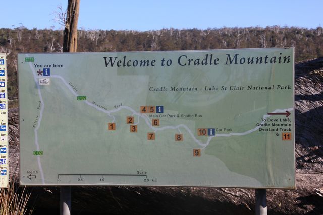
WELCOME TO CRADLE MOUNTAIN... if you look at the sign, the shuttle bus runs from the numbered 5 area which is the information centre. It's 2klms to the numbered 10 area which is where the boom gate is located, and then another 8klms from there to Dove Lake


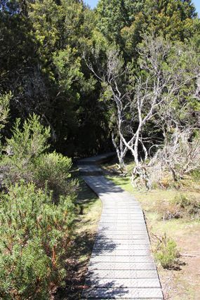
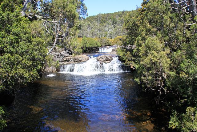
Arriving at the information centre we notice the car park is absolutely packed, it seems as though half of the population of Tasmania is here today. We park our vehicles and go inside the main building to try and see how this place operates. We find out that in order to catch the shuttle bus you need to have purchased a National Parks visitors pass, we'd already purchased these on the ferry at the start of our trip as we came from Melbourne to Tasmania, so all we need to do now is show them to the Rangers working behind the counter here, and they give us some tickets to ride the shuttle bus. We then head towards the shuttle buses and see a big queue of people waiting to get on them, we don't have time to wait as long as it will take to get on the shuttle buses, so we head back outside to our vehicles. I know i've mentioned the boom gates stopping access to the lake already, but first up this morning we aren't heading to the lake, we need to head to Cradle Mountain Lodge instead (numbered 9 on the map above). The lodge is located just before the park boundary and thus before the now closed boom gate, we need to head here to drop both the wives and my eldest daughter off, as the 3 of them are going horse riding this morning. On the way to Wings Wildlife Park the other day we made a few phone calls and booked the horse riding adventure for them, the ride goes for about 2 hours and costs $120 per adult and $95 per child (under 16 years old). We arrive at the lodge with some time to spare before they get picked up to go to the horse riding location, so we decide we'll go do a short walk located here called The Enchanted Walk, it's only just over a 1 klm in length and takes about 15 minutes to do. The walk is very easy going and mostly done on a boardwalk, if you do the circuit anti clockwise you'll finish up at a nice little waterfall which is located by the roadside just before you drive into the lodge car park area.

THE ENCHANTED WALK AT CRADLE MOUNTAIN LODGE


NICE LITTLE WATERFALL YOU SEE NEAR THE LODGES ENTRANCE ON THE WALK


With the walk completed we make a plan to meet up back here at a certain time and then say goodbye to the other 3. Jeff, Myself and other 3 kids then head back to the info centre to catch the shuttle bus up to Dove Lake.
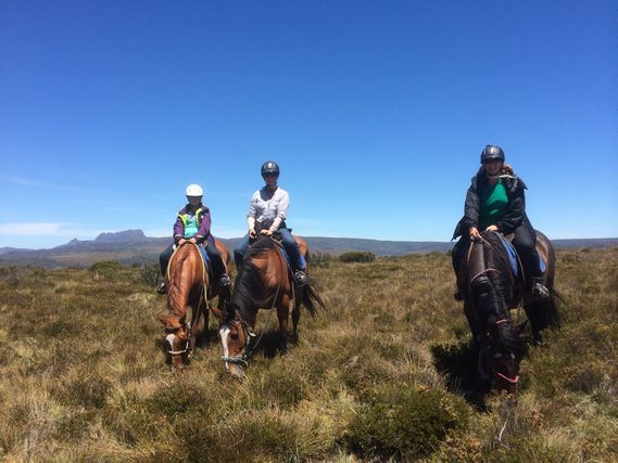
I just now asked my wife how the horse ride was as i can't make comment on having not done it myself....she said the views were pretty nice along the way, and she seemed to like having done it. Asking my eldest daughter just now also what the ride was like was a complete waste of time, she reckons she can't remember to much about it...bloody kids hey...lol

OUR ELDEST DAUGHTER ON THE HORSE RIDE


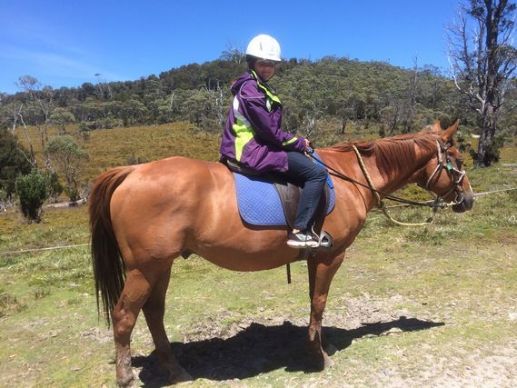
THE 3 LADIES ON THE HORSE RIDE, WITH CRADLE MOUNTAIN IN THE BACKGROUND


Arriving back at the info centre, there's even less carparks here now then before for Jeff and myself to park in, we manage to find a couple of the last remaining car park spaces here and then park the vehicles up and walk up to the shuttle bus departure point. The line up for the bus hasn't gotten any smaller since we were here earlier, it takes about 20 minutes to get to the front of the line, but eventually we are on one of the buses heading up to the lake. As we pass by the boom gate that stopped us driving our own vehicles into the National Park, it quickly becomes obvious why they run the shuttle bus and boom gate system here that they do. On days like today with the amount of people they have in the park at the moment, the road to the lake would become grid locked due to how much of it is single lane. The shuttle bus drivers talk to each other over the uhf radios they have onboard, they then know where each other is in the park, and thus pull up at certain passing bays along the way and allow the oncoming bus to reach the passing bay before continuing on. There's several places to disembark the bus along the way to Dove Lake, you can do various walks of different lengths at these drop off points, but be warned....on a day like today when everyone else like us is heading up to the lake, there are no vacant seats on the buses, so they can't stop to pick you back up and shuttle you to your next location. You may have to wait at these spots for quite a while for a vacant seat to be available to continue on to the lake, or you may even have to jump on a bus headed back towards the info centre instead...we saw many people waiting at these locations and the buses just drive past without stopping, as they had no vacant seats onboard.
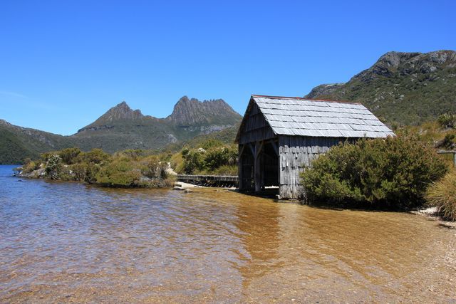
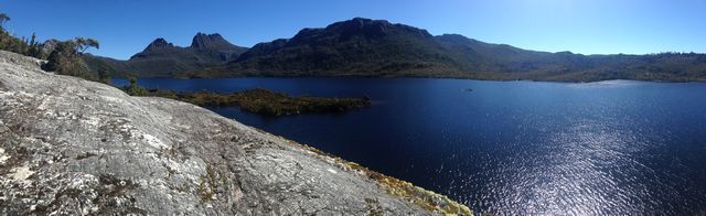
Arriving at Dove Lake we disembark the bus and head on down towards the water, it's a stunning day right now and there's people absolutely everywhere we look. There's several walks you can do here if you so desire, the most popular and easiest being a circuit walk of 6klms in length, it takes you right around the perimeter of the lake. We'd like to do this walk ourselves, but sadly can't with the 2 year old child we have with us....it's just be to far with it being that distance in length. A few quick pics taken here and we start to walk anti clockwise around the circuit track to the much photographed boat shed that is located on the lake. The boat shed was built in 1940 by the first Ranger at Cradle Mountain, Lionell Connell. The shed has undergone some restoration work in 1983, but it remains substantially unaltered from its original form. These days the shed is basically just a prop in the foreground of peoples photographs of Cradle Mountain, but up until the 1960's boating was actually quite a popular past time on Dove Lake, and thus explains the sheds existence.
Arriving at the water by the boat shed to get that iconic photograph many people have of Cradle Mountain, we are disappointed to see how much rubbish is scattered amongst the shrubs here from lazy grub tourists that can't be bothered doing the right thing and taking their rubbish out with them. To be in such a pristine place with a lovely view as we see before us, then see all this crap sitting in under the tree bushes really peaves me off to no end....i can't understand how people can come to such a beautiful place and then just throw their rubbish on the ground, thinking it must just magically disappear or something.
My rant now over...I wait and wait, and then wait some more... then eventually i finally get a chance to take a picture of the boat shed with no people in it. The circuit walk track actually passes right beside the shed, and with the amount of people at Cradle Mountain today, trying to get pics with nobody in them is a pretty tall ask. I eventually get the pics i am after and then have a quick snack to eat in the shade of a tree with my youngest. It's now already time for us to start heading back to the shuttle bus pick up point, so we can get to our vehicles and go pick the other 3 up from their horse ride. We haven't looked around here very much at all, but we plan to come back here later with the other 3, and hopefully the crowds will have died some by then.
The wait at the pick up point for the bus is not as bad as it was to come up to the lake, it only takes about 10 minutes wait this time and we are back on a bus headed for the info centre.

THE BOAT SHED AT CRADLE MOUNTAIN


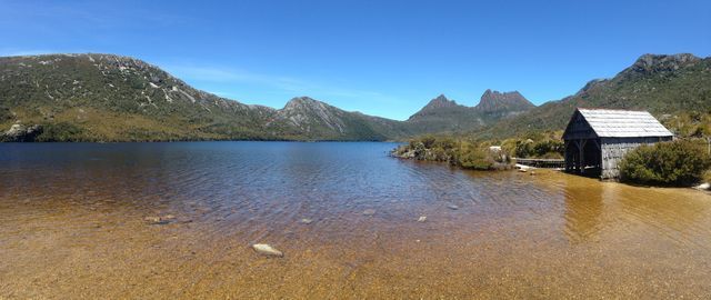
A WIDER VIEW OF THE LAKE AT THE BOAT SHED


Back at our vehicles at the info centre, and we head on back to the lodge to pick the other 3 up. We haven't had lunch yet today and it's nearing 3 p.m already, so we park the vehicles in the car aprk of the lodge and head into the pub they have here to get a bite to eat. The women aren't back from their horse ride just yet, so we grab a beer and a burger each (juice for the kids though...lol) and wait for the others to arrive. Just as we finish eating lunch the others find us inside the pub, they haven't eaten lunch yet either, so order something to eat for themselves also.
Lunch finally eaten by all we head to our vehicles and then try our luck driving ourselves up to the lake. Luck is on our side, and the boom gate is now open, allowing us to continue on driving to the lake. We arrive at the lake and the ladies want to go visit the boat shed, being Jeff and myself have seen it already, we leave them to go in that direction around the lake, and we head off in the opposite direction to go check out Glacier Rock. The walk to Glacier Rock is pretty easy going, it's roughly about the same distance walk away as the boat shed was in the opposite direction, and before we know we have arrived there. The view out over the lake below is pretty stunning from a top the rock, but very careful up here if you have kids with you, as there's no protection at all to stop anyone from tumbling over the edge to the rock and water below. There's a small gate located at the entrance to the Glacier Rock area that has signage warning about the sheer drops here, so once you walk through that gate you'll need to keep a good eye on your youngsters.
We have the rock area to ourselves for a while taking pics and enjoying the view before the next lot of visitors arrive, we take this as being a sign it's time for us to start heading back towards the others, so we that's just what we do.

THE VIEW OVER DOVE LAKE WALKING TO GLACIER ROCK


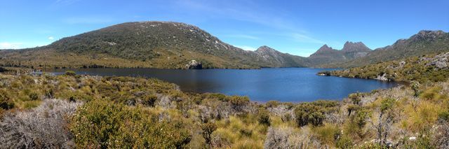
CRADLE MOUNTAIN AND DOVE LAKE AS VIEWED FROM GLACIER ROCK


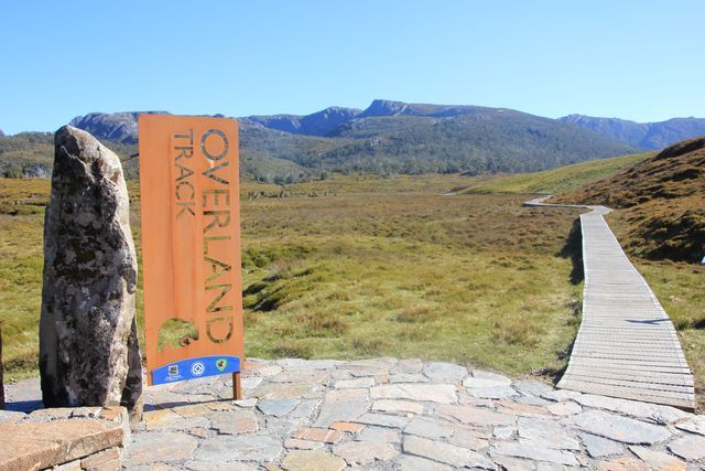
Arriving back at the car park area we meet up with the others and decide it's time to start heading back towards camp, Jeff and Sara head off first as they want to get some milk and a bottle of wine from a shop somewhere, and we leave a few minutes behind them saying we'd meet them back at camp. As we drive back towards the information centre, i stop off along the way and grab a pic of the starting point of the Overland Track, this is one of Australia's most famous walks, and takes hikers about 5 - 6 days to complete the trek. From this starting point it's a 65klm journey to Lake St Clair which is where the track ends, you may recall we'd visited this lake back on day 15 of this holiday. The Overland Track must be walked in a North to South direction, and is usually done between 1 October and 31 May, amazingly the record time for completing this walk is 7 hours and 25 minutes...i doubt the record holder took in much of the surrounding beauty along the way though.

START OF THE OVERLAND TRACK.....it's 5 - 6 day trek to Lake St Clair from here


Back in the vehicle once again and we leave the National Park area behind us, as we get close to the info centre i see a car parked in the middle of the road blocking our lane. I get a clear bit of road from oncoming traffic and drive around the vehicle, thinking what a stupid place for someone to stop....no consideration at all for others!!!. Just a touch further on we catch back up with Jeff and Sara, who ask us over the uhf radio if we saw the wombat that was back down the road a touch, it's at the moment i then realise that's why the vehicle was stopped in the middle of the road where it was, and we'd just missed our opportunity to see our first ever wombat in the wild. Jeff and Sara had the wombat cross the road pretty much right in front of them apparently, by the time we'd come past the same spot it was down in a culvert by the roadside, so wasn't able to be easily seen and why i had no idea why the car was stopped there.
Wombat viewing opportunity missed, we continue on heading back to camp. Sara mentions to us on the drive back to camp that they'd stopped in at the info centre to try and find out where they could buy what they wanted in the area, the lady working at the information centre was pretty rude apparently, and absolutely no help at all. She then ended up at a backpackers place trying to buy the wine, but because they weren't staying there, the manager said they couldn't sell it to her. Reaching our turn off to head back to camp, Jeff and Sara continue on driving into Moina which is only about a kilometer further down the highway. We turn off and head straight back to camp, and when the others arrive back here they mention how nice and friendly the owners of the tavern were, and how well stocked their wine range was.....so if you're in the area and after some supplies, be sure to stop in at the Moina Tavern.
Jeff and myself grab some more firewood and get the fire going, we have dinner and whilst eating it Sara thinks she sees a big fish in the water beside us. On closer inspection we quickly realise it's not a fish but a platypus, we see it several more times duck diving in the water nearby but don't manage to get a photo of it, before it then disappears for the night. We may have missed our opportunity to see our first wombat in the wid today, but for us this is actually the first ever time we've seen a platypus in the wild. We've (my family) been to many spots over the years where platypus supposably live but never seen one, so to see one in the wild for the first time at such a beautiful location, and literally metres away from where we are camped, was pretty amazing.
The rest of the evening is spent sitting around the fire as the clouds start to move in, the forecast for the coming days has rain coming, so we'll have to see what tomorrow brings i guess.
 

Rumpig

Adventurer
DAY 30 - LAKE GAIRDNER TO ?

Waking around 5.00 a.m to answer the call of nature i note it's not a bad day, and nothing like the rain that was predicted for today. I head back to bed and when i wake a few hours later i am surprised to hear rain falling on the canvas of the camper. Exiting outside the camper and the weather has turned completely, it's cold, overcast and raining...nothing like it was a few hours ago. We have some breakfast and notice the platypus is out and about again today, it's swimming around a heap this morning, and i manage to snap a very average pic of it inbetween rain showers. The platypus appears to have a burrow under the trees hanging over the water, across the other side from camp a short distance away, it keeps heading back to the same location time and time again, so we assume that's where it's home must be located.

THE PLATYPUS WAS BACK AGAIN THIS MORNING


As we have breakfast the rain really appears to have set in now, looking at the weather radar on my phone shows no sign of it letting up anytime soon, so it looks like we'll be packing the camper trailer up wet this morning, as we are moving on today. Days like today is where a camper such as what Jeff owns, is a much better option to have then what we own. Jeff can just about pack his camper up completely without the rain that is falling effecting him to much, where as we need the rain to stop falling really, or else water pools in the middle of the canvas as we fold our trailer up shut...and that can lead to water getting inside and wetting our bedding.
We hold off packing up as long as we can and pack up everything other then the trailer itself. Watching the radar i see a very small window of opportunity coming where the rain will hopefully stop for a short while, or atleast slow to a drizzle, and when it comes we make the call and hastily pack the camper trailer up closed. We time it to perfection, and whilst the rain hadn't stopped completely, it had slowed to a light drizzle...so we managed to get the trailer closed up without to much water pooling everywhere. I've had the diesel heater running inside the trailer all morning to try and help keep the canvas from getting to wet, it appeared to be helping some, but i guess we'll find out what our bedding is like when we re-open it at the next camp spot later this afternoon. We do have a plastic type cover sheet we put over the bed when we pack it up to help protect the bedding from getting wet, this along with the carpet floor covering that the kids sleep on, which we put on top our bed at pack up time should keep the bed dry, but you just never know if water gets in or not when you pack the camper up in the rain.
We leave camp around 11.00 a.m and head back to Cradle Mountain Rd, we turn left onto it and head into Moina, then turn right onto Cethana Rd. A short distance down this road we see a sign for a lookout, so we take a quick right turn and head down that road to see what's there to see. Arriving at the end of this road and we see it's a lookout with a view over Lake Cethana, you can see the dam wall down below, but the rain that is currently falling and the low level cloud make it not the best viewing conditions today. It's cold and wet outside right now, so we only have a very quick look at the view before jumping back into the vehicles where the heater is running to warm us back up again, we re-join the main road and continue to head Eastwards.

TODAYS VIEW OF THE LAKE CETHANA DAM WALL


You may have noticed in the title i haven't added a destination for todays drive, well that's because we don't actually know where we are going to stay the night tonight. Our plan for today is to head somewhere close to Launceston to stay the next few nights, we've got a few places we want to visit around that general area, but we've made no plan of an actual location to stay at. Todays general plan is to visit a few locations along the way towards Launceston, we will stop at the towns of Sheffield and Railton along the way, and then we'll see from there where the day takes us. Somewhere along the way to Sheffield we make a quick stop off at a park and toilet block along the way, we take the opportunity to empty out our rubbish bags into the large bins they have here, and we take a pic of the metal statue they have infront of the park, before continuing on our way.

METAL MAN STATUE WE SEE AT THE PARK


From here it's an uneventful run into the town of Sheffield, the weather is miserable outside, and spending the day inside a nice warm dry vehicle at the moment is a pretty good option i am thinking to myself. We park the vehicles up in a large car park area in a back street of the centre of town, we want to have a look about the town as it is nowadays known as the town of murals. Back in the early 1960's Sheffield was a town that grew rapidly due to the seven dams and seven power stations that were built around this area as part of a power generation scheme. But on completion of this scheme the population of the area declined, and local residents decided they needed to come up with a way to attract people back to the area. Having heard of a small Canadian town in a similar predicament reviving itself by painting murals on the towns buildings and having tourist come visit the area to see them, Sheffield has done much the same thing, and today is a bustling little township that annually attracts an estimated 200 000 people to the town to see it's murals. The first mural painted on a building in Sheffield was done back in December of 1986, today there's over 60 murals you can view here, just walk around the town and you'll see them everywhere you look.

JUST A FEW OF THE MANY MURALS YOU CAN SEE IN SHEFFIELD


Sheffield is a decent sized little town these days, we take the opportunity to do some shopping whilst here, we need to buy some gum boots for our youngest daughter to run around in the water puddles at the moment, and i need some new long pants to wear after ripping the crutch out in mine the other day climbing up to get something off of the roofrack of my vehicle. We find a shop that sells what we want before then moving on to the World of Marbles just down the end of the street a touch. The World of Marbles shop is free to enter into, it's a shop selling hand-made art glass marbles aswell as a heap of other items also. Some of the mechanical toys they on display here are pretty fun to play with, they're are pretty hard to explain, so watch this link to get an idea of what i'm talking about https://www.youtube.com/watch?v=6t6fotDL8-I
Our look around Marble World complete and it's now lunch time, it's still cold and raining outside, so we choose to head to the bakery just up the road and grab a nice hot pie for lunch to warm us all up. The bakery is pretty big, it has a dine in area you can sit down at to eat your meal, so we do just that to stay out of the rain. With lunch eaten we head back to the vehicles so we can leave town. On the way out of town we take a detour to the Apex Park in Spring Street so we can empty our chemical toilets at the dump point, the rain stops just in time for us to do this fun job, and before long we are back in our vehicles once again and headed for the town of Railton. Railton is only about 12 klms down the road from Sheffield, it's a much smaller town then Sheffield is, but has it's own tourist attraction here to bring people into the town. Railton calls itself the Town of Topiary, and when you visit here you'll soon realise why. Throughout the centre of town and in peoples front yards also, are a heap of different shrubs that have been transformed into all sorts of shapes and animals. Don't just stay on the main road in town here, duck down the side streets and you'll find so many different topiary set ups, it's mind boggling. The rain doesn't make it an inviting day to walk about the town, so we do a tour of the place looking out our vehicles windows in amazement, before then pushing on once again towards Launceston direction.

NORMAN SYKES TIMBER STATUE ON EDGE OF TOWN AT RAILTON......this staue was erected in dedication of Norman Sykes who donated 15ha of bushland to the young people of Railton. The land was left to be used as a sanctuary for birds and wildlife, and so that future generations could enjoy it for recreational purposes


THE TOWN OF TOPIARY


SHRUBS LIKE THIS ONE LINE THE MAIN STREET OF TOWN


JUST A FEW OF THE THINGS YOU'LL SEE IN PEOPLES FRONT YARDS


Our tour of Railton done we leave town via Railton Rd, and we then eventually turn off of that onto Gannons Hill Rd and take the scenic route that hooks us up with the Bass Hwy. Turning right onto the Bass Highway we continue our Eastward drive and soon find ourselves turning right off of the highway to pay Ashgrove Farm Cheese a visit. The cheese farm is open every day except Xmas day from 7.30am to 5pm, it's about 40 minutes drive out of Launceston, and you can buy a range of cheeses here, aswell as try thier ice-cream, fresh bottled milk, cream and butter. A few types of cheese purchased here and we are on our way once again.
Next stop for us today is at the Cristmas Hill Rasberry Farm, we stop in here as Jeffs oldest boy absolutely loves eating berries of all descriptions, we are a touch disappointed with what we find here though, it's basically a cafe selling a few tubs of berries at not that cheap of a price. We don't bother to buy anything from here and walk outside, across the road we see a place called Van Diemens Land Creamery, it may be a cold and wet miserable day today, but it's never to cold to have ice cream i reckon...lol. We head on across the road and try out some of the gelato ice cream they sell here. Taste testing done, we grab an ice cream cone each and Jeff even buys a tub of ice cream to take with him aswell.

VAN DIEMENS LAND ICE CREAMERY... Van Diemen's Land was the original name used by most Europeans for the island of Tasmania. In 1803 the island was colonised by the British, and then on the 1st of January 1856 it's name was changed to Tasmania.


We walk outside to our vehicles and give the caravan park in Longford a call, they have some vacancies at their park for powered sites, so we book ourselves in here and then head off to drive the 45 klms that it is from here to Longford. The drive to Longford is uneventful, it's a highway run for the most part, and before long we are pulling up outside the parks entrance. We book ourselves in and then back our trailers onto the sites we have been allocated for the next few days. I unhook my vehicle from my camper trailer and then get about setting up the camper, the canvas is quite wet from this mornings rain, but all our bedding appears to be dry. The weather has started to clear now so i fire up the diesel heater and zip the windows and doors up to keep the heat in, i let it run for the next few hours, this will dry the canvas out nicely so we don't have wet walls to touch when we go to bed tonight.
Looking at my fourby i'm not happy with how close i've left it to the front of our trailer, i jump into it and try to start the vehicle, but all it does is wind over but not actually start. It appears as though it's got plenty of battery power getting to the motor, but for some reason it just doesn't want to kick over. Jeff and myself check under the bonnet to see what we can see, nothing appears to be obviously wrong with the vehicle as we look around the engine, we try to start the vehicle several more times, then all of sudden it decides to fire up when we try the key one more time. We have no idea what was wrong with the engine to make it act as it did, i move the vehicle forward a touch then shut it off once again. For now the vehicle seems to be ok, but all this will change as the holiday goes on, something i didn't realise at the time. We settle in for a relaxing evening and even get to view a nice sunset.
We chose to stay at Longford due it's close proximity to Launceston, all the reviews we'd read about staying in the caravan parks at Launceston mentioned the noise of the nearby highway, so we thought we'd give the place a try seeing it's a pretty small town and the park is located right on the banks of the Macquarie River. The caravan park is by no means cheap for a small town, one thing we didn't expect after paying a premium to stay here, was that you need to put extra money into the showers to get hot water...******!!!!!
I'll give the park credit where it's due, it's a nice enough caravan park that is well maintained and very clean, it's situated literally right beside the river and many of the sites here have water views.....but to charge us extra to have a hot shower after charging a premium to stay here is down right rude IMHO, i doubt i'd ever stay here again just for that very reason.
Rant over...we spend the rest of the evening relaxing at camp, have dinner and few drinks then head off to bed for the night
 

Rumpig

Adventurer
DAY 31 - LAUNCESTON

Keeping with our relaxed pace we've been setting on this holiday, it's another slow start to the morning for us today. This holiday has been a nice change from doing what we usually do on a touring holiday... normally we are up earlyish and trying to get on the road to go somewhere as early as we can, but this holiday has seen us sleeping in most mornings, and there's no rush to go anywhere...it's quite relaxing, how a holiday is supposed to be i guess.
Weather wise it's a nice day today, the rain from yesterday is long gone and the sun is shining. Today we plan to drive in to Launceston to visit a few places, from where we are staying in Longford it's only about a 25 klm drive away, so not very far at all really. We have some brekky and then head off to Launnie for the day, Jeff needs to drop a tyre off at the local tyre store in Longford as we leave town first up though. One of his tyres developed a slow leak a few weeks back he noticed, we changed it over for the spare whilst camped back at Mt Field, and now it's time to get the leak looked at and repaired. I leave Jeff to drop the tyre off and head onto Launceston where i'm going to grab a new fuel filter for my vehicle, i'm pretty sure this had nothing to do with why my vehicle wouldn't start yesterday arvo, but i'm thinking i'll grab one whilst we are in a large town just to be safe. Jeff seems to think it's a sticking solenoid problem in the fuel pump or something along those lines, the vehicle started fine this morning first go, so we'll see how it goes today i guess.
I drive to Repco in Launceston and grab the new fuel filter. Jeff also needs to go to Anaconda to grab a new latch for his Waeco fridge, i rang them from camp for him this morning and they have the part he is requiring. Knowing Jeff needs to go to Anaconda we make that our meet up point, so the plan is to head there now from Repco. I say that's the plan because in order to go there i first need my vehicle to start, and low and behold what do you know....jumping back into the vehicle and turning the key it just winds over and won't start. I pop the bonnet and give the fuel pump a few taps with a big screw driver thinking it's a sticking solenoid, i try the key again and no luck it won't start. I tap it a few more times and try the key, and what do you know the vehicle roars to life. Vehicle now running once again we head over towards Anaconda to meet back up with Jeff and family.
Anaconda is actually right down the road from the first tourist destination we want to visit today, which is the Boags Brewery. With Jeff parked in the car park of Anaconda, i look to park my vehicle nearby out on the street somewhere. We find that all around the area is metered parking and it costs $3.60 an hour to park out on the street, where Jeff is parked in the shopping centre 30 metres away from us is also a pay to park location, but it's only $2 for 2 hours in there, so we park in the shopping centre carpark and pay the $2 instead. I give Jeff the bad news about the vehicle not wanting to start again at Repco, we decide to just forget about it for now and walk to the Boags Brewery down the road, after our visit there i'll give a mechanic or diesel shop a ring and see what they have to say.
The Boags Brewery is literally only several hundred metres walk down the road from where we are now parked. The brewery was established back in 1883 by James Boags and his son, who was also named James. It was run by Boags family members right up until 1976, but these days is owned by the San Miguel Corporation. Whilst i myself am not a beer drinker, my wife loves drinking Boags and so does Jeffs wife Sara also, so that is why we are making the visit to this brewery today. You don't need to be doing a tour of the brewery to come visit here, children under the age of 5 aren't allowed on tours anyhow, so we ourselves have no plan to do a tour of the brewery as such. Located at the brewery is a free to visit onsite museum, we have a look around inside here for a while learning the history of the brewery etc, and then also spend some time checking out the architecture of a few of the old buildings, and an also checking out an old truck we find in the car park also. When we venture out the back of the museum building, the wives think they have died and gone to heaven...i'll let the pic below do the explaining...lol

THE BOAGS BREWERY...like 2 kids in a candy shop, they were...lol


A BIT OF SIGNAGE ON ONE OF THEIR BUILDINGS


ONE OF THE DISPLAYS INSIDE THE FREE TO VISIT MUSEUM


I THINK THEY THOUGHT THEY'D DIED AND GONE TO HEAVEN WHEN WE FOUND THIS...LOL


A BEAUTIFULLY RESTORED OLD BOAGS DELIVERY TRUCK ...i assume that's what it used to be once upon a time


With our look around the brewery done we head back towards our vehicles. Arriving back at the carpark i call a local diesel mechanic on my mobile phone and speak to him about the problem i am currently having with my vehicle. The mechanic automatically starts talking about the pump possibly needing rebuilding, a job i know will likely cost several thousand dollars on a vehicle such as i have. Not happy with that being his line of thinking straight off the bat, we decide to give visiting him a miss and we'll head around the corner to the pub for lunch, and have a bit more of a think about the problem there. We walk over to a local pub a short distance away and order a meal and a drink, whilst waiting for my meal to come i start surfing the net on my phone and jump on LCOOL forum (a dedicated Landcruiser forum), and try and find similar threads relating to the issue i am having with my vehicle. I vaguely recall reading ages ago on that forum, about issues with immobilisers and vehicles not wanting to start when the engine is hot / warmed up to running tempeature, so i search through some old threads and find exactly the information i am chasing. Reading these old threads on that forum it appears as though the immobiliser is the problem, when vehicles get around the age my vehicle now is, the immobiliser starts playing up and won't let the vehicle start when the engine has gotten hot. I take screen shots of several pages of that forum on my phone to use as a reference later on down the track, should i need to try and bypass the immobiliser. It appears as though the problem is going to get worse and eventually the vehicle just won't start at all, even when it gets cold, but atleast now we are pretty confident we know that's the problem. Between Jeff and myself, we think we can work out how to bypass it should the vehicle get to a point where it doesn't start at all, for now though we aren't going to touch the immobilser at al, because in order to bypass it we need to smah it apart, something we don't really want to do on this trip if we can avoid doing so.
I eat my lunch whilst doing some more reading up on the issue, and with lunch finished we then head back to our vehicles once again. From here we are heading a short drive away to Cataract Gorge, it's only about a kilometer and a half out of the city centre, and a pretty popular tourist destination for anyone who visits Launceston. We park the vehicles up in the car park area here, once again you need to pay to park, so we pay the fee and then head on into the park. Located here in the gorge is quite a few different things you can choose to do, there's a large swimming pool you can swim in, some cafes, some walks to do and what supposably is the longest single span chairlift in the world you can pay to ride on also. We have a quick look around the cafe area and information centre, before then heading back over to the chairlift and going for a ride on it. You can choose to do a return ride if you want to, but we are only going one way, then we'll walk back to our vehicles via the suspension bridge located here also once we've explored the area a touch. The chairlift costs $36 to do the one way trip for our family ($50 for a return trip), it's not a cheap ride to do by any means, but it's not like there's that many chairlifts left you get the chance to ride on these days, so what the heck we think. As you ride the chairlift you cross over the parkland below and then over the South Esk River (the longest river in Tasmania), if you look to your left you'll get a nice view looking up the gorge.
We reach the other side of the chairlift and disembark, we then spend some time looking around the gardens here, before then making our way back towards the suspension bridge.

CATARACT GORGE CAHIRLIFT


LOOKING LEFT ON THE CHAIRLIFT UP THE GORGE


WE EXPLORED THE VICTORIAN STYLE GARDENS FOR A WHILE


AND I WONDERED HOW MANY GENERATIONS OF FAMILIES WOULD HAVE SAT ON THIS STAGE COACH OVER THE YEARS?


ONE OF THE MANY PEACOCKS WONDERING ABOUT THE GROUNDS HERE


We walk back to the suspension bridge and stop at a small lookout area along the way, crossing the bridge it would be nice to do the walk up the gorge that takes you to the old Duck Reach power station, but the afternoon is getting away from us now and the kids have just about had enough walking around for the day, so we head back to our vehicles.
Back at our vehicles we then drive back to Longford, we make a quick stop off at the IGA store to grab some supplies for tonights dinner, it's a decent sized store and is pretty well stocked. From the IGA we head past our turn off to camp and head over to look at a church i spotted yesterday as we arrived in town. I take a few pics of the church and we then drive around the corner to the local hardware store, where i grab a small tube of silicone to repair a hole i saw in the camper trailers sealant the other day as i packed it up. From here we head straight back to camp, i grab a drink from the fridge and use the silicone to repair the hole i'd spotted in the sealant. A few more drinks had and dinner also, we then head off to bed not to late, as it's a touch cold outside tonight.

THE CHURCH WE STOPPED OFF TO LOOK AT AROUND THE CORNER FROM CAMP IN LONGFORD


Rumpig

Adventurer
DAY 32 - VISIT LOTS OF PLACES AROUND THE GENERAL LAUNCESTON AREA

We have a bit of a sleep in this morning, then eventually get out of bed and have some bacon and eggs for brekky. Leaving camp around 10.30 a.m we are first headed for a place called Jacobs Ladder which is located in the Ben Lomond National Park, roughly about 60 kilometres from Launceston. Jacobs Ladder is the name given to the single laned zig zag road that climbs up Ben Lomond Mountain, and this road takes you to the Ben Lomond ski village.
Leaving Longford, we first head through the town of Perth without stopping here, then onto the historical town of Evandale. Evandale is classified as a historic town due to many of its buildings remaining largely in original condition. It's a pretty little town worth stopping off at for a look around, but we only stop briefly to get a few pics of some buildings as we pass through, and then continue straight on for Ben Lomond National Park. You can head to Ben Lomond via the bitumin if you like, but we'd noticed there's a more direct dirt road route to take, so that's the way we go.

EVANDALE WATER TOWER


ST. ANDREW'S CHURCH OF ENGLAND IN EVANDALE


Rejoining back onto the main bitumin road after our short scenic dirt road route is completed, we finally get to see our first wombat in the wild...it's just a shame it happens to be a dead bloated one in the middle of the road. We swerve around the dead wombat and continue on driving, and pretty soon we get a glimpse of Ben Lomond mountain in the distance. The rolling countryside and mountain backdrop view is quite scenic as we drive along, but going by the low cloud cover we are seeing on the mountain in the distance, we are concerned that we aren't going to be able to view Jacobs Ladder from the lookout that's located at the top of it. There's not much we can do about the weather, so we just keep on driving and hope the clouds will lift at some stage whilst we are there.

BEN LOMOND MOUNTAIN IN THE DISTANCE, SHROUDED IN LOW CLOUD COVER


We soon arrive at our turn off, and then turn right off the main road onto Ben Lomond Rd. Immediately we are greeted with a warning sign regarding the conditions one can expect to encounter here in the Winter period, and from memory the bitumin ends here also, so it's a gravel road from here all the way to the top of the mountain.... (if i'm incorrect on the gravel starting here, it's only a very short distance before it starts anyhow). We stop here beside the sign briefly whilst Jeff mounts his GoPro camera in position on his vehicle to capture the drive up Jacobs Ladder, we then head off and start winding our way up the mountain. This mountain is the second highest mountain in Tasmania at 1,573 metres, only Mt Ossa in the Cradle Mountain - Lake St Clair National Park is higher then it. Making our way upward, traffic is non existent and we soon pass by the sign welcoming us to the National Park.

WARNING SIGN AT START OF BEN LOMOND ROAD


WELCOME SIGN AT BEN LOMOND NAT. PARK


About a kilometer past the welcome sign we take a track leading off to the left of the main road, this takes us into a campground for a quick look around. We jump out of the vehicles here and straight away you can feel the temperature differance from where we were back at camp earlier this morning, most of us are quickly reaching for jumpers or jackets we have in our vehicles. Even though it's the middle of Summer currently, it's a touch cold if you were to be camping here, but if you did so you'd have the place to yourself at the moment. I'm not going to say it's the most beautiful campground i've ever seen, it'd make an ok overnight spot if you were looking for somewhere to stay about the area, and it doesn't really look to get a lot of people staying here, so chances are you'd have the place to yourself most times. Theres 6 unpowered sites located here aswell as a flushing toilet, there's also a small lookout near the toilet building also, but the low cloud cover makes the view pretty average for us today.
We jump back in the vehicles and continue our run up the mountain, we soon take a turn off to our right from the main road and find ourselves looking at Carr Villa Lodge, which going by the signage we see on the front of the buildings, is owned / run by the Scouting movement. The building is boarded up shut , there's nothing to see here so we turn around and continue our drive up the mountain. The drive up the mountain so far has had the surrounding forest enclosed on either side of the road, but once past Carr Villa the trees start to disappear and shear rock walls can be found on our righthand side, and steep drop offs are to our left.

THE ENCLOSED ROAD DISAPPEARS ONCE YOU GET PAST CARR VILLA


The low cloud we'd seen earlier encompassing the mountain has started to clear some as we near Jacobs Ladder, we stop for a few pics of the jagged rock faces rising high into the sky to our right as we go along, and then before we know it we soon reach the start of Jacobs Ladder itself. We stop here for another quick pic then start the zig zag climb to the top, vehicles going up must give way to the vehicles coming down, there's room on the hair pin corners for vehicles to pass each other, but inbetween the turns it's single lane only. Lucky for us there's nobody else about the place today at the moment, so we get to do the drive at our pace and enjoy the spectacular view as we go along. Well when i say "we" enjoy the view, i probably should have said everyone except my wife enjoyed the view...you see the entire way up Jacobs Ladder she was absolutely freaking out big time, she was worried i was going to drive off the edge of the road and we'd plummet to our death, and my occasionally jerking the steering wheel towards the edge as a joke probably didn't help her situation much at all either i'll add here...lol. I've read of Jacobs Ladder being called one of Australia's "most dangerous roads", but to be honset here... if you drive the road at a sensible speed then at this time of year you have absolutely nothing to worry about, it's a very easy scenic drive. Obviously in Winter the road would be a completely different road to drive if ice or snow was about the area, but on a day like today, you'd need to be doing something pretty stupid to crash your vehicle on it.
Even with my wife freaking out big time in the passenger seat due to the big drop offs beside her on her side of the vehicle, we safely make it to the top of Jacobs Ladder, we park the vehicles up and hop out for a look at the view from the lookout that is situated here. I choose to leave my vehicle running the entire time we are here, i can't risk it not starting when we want to leave, so i leave it running and go check out the awesome view from the lookout platform. Luck is very much on our side as far as the cloud cover clearing goes, the sky clears enough to take some pics of the windy road below, and then after about 15 minutes the cloud cover comes right back in again and visibilty drops big time.

A WARNING SIGN AT JACOBS LADDER


LOOKING DOWN FROM THE LOOKOUT AT JACOBS LADDER


With our look over Jacobs Ladder complete we jump back in the vehicles and keep on heading up the mountain, we actually have no idea at all what's up the top here, so we decide to keep heading upwards and see what we can find. Now you may recall i just mentioned the cloud cover coming in and visibility dropping big time at the lookout, well as we climb higher the visibilty gets to be only about 10 metres infront of the vehicle, i actually resort to using the orange coloured snow plough guide posts to keep me on the road. Jeff reaches the top first and i radio him on the uhf to see where he is, he tells me he can hear me coming up the mountain, but he can't see me at all...lol. I soon catch up with Jeff and find he's stopped outside of a cafe building of some description, i read the sign out front of it, and it proclaims this is actually Tasmania's highest pub that we have found ourselves at. Seeing as we've had a drink at the Southern most pub and oldest continually licenced pub already on this trip, we thought we may aswell add the highest pub in Tasmania to our list of places we've had a drink at...so we park the vehicles up and jump out to go inside.

SOME PRETTY YELLOW FLOWERS BY THE ROADSIDE ON THE CLIMB UP THE MOUNTAIN PAST JACOBS LADDER


VISIBILTY GOT PRETTY ORDINARY THE HIGHER WE CLIMBED


AND THEN WE SURPRISINGLY FOUND OURSELVES AT TASMANIA'S HIGHEST PUB


THE PUB IS ACTUALLY AROUND THE BACK OF THIS BUILDING


We walk inside the pub and I go to order a drink for us each, i grab my usual drink of Bundy and Cola but it's right then the wife tells me she wants a ******** inside her...****** i think to myself, geez love the kids are here.....whoops, apparently i misunderstood what she was saying... what she meant was she wanted a Dickens Cider, my mistake...lol. (Can't wait till she reads this, i'm going to cop it big time...lol) https://www.youtube.com/watch?v=dqRRW9lKmEQ

DICKENS CIDER...yes it's a real drink...lol


We grab our drinks and sit down for a while and enjoy the warmth that the fire place is putting out. I then walk outside for a bit of a look around, and as i do this the cloud cover starts to lift a touch. Suddenly out of nowhere buildings start to appear one at a time, the more the cloud cover clears the more buildings we start to see, and suddenly we realise we are in the middle of a village. We had absolutely no idea these other buildings were all around us, we literally could only see the building we are in when we arrived here, it was quite surprising to see these other buildings suddenly appearing out of nowhere. Just as soon as the cloud cover starts to clear it rolls back in again though, so we head back inside to finish our drinks and warm up once again. Drinks finished and it's time to head off back down the mountain, it's fingers crossed my vehicle will start, i turn the key and it thankfully fires into life. The visibilty is still quite ordinary as we leave, i use the orange guide posts once again as my reference point to stay on the road, but once we reach Jacobs Ladder visibilty then becomes pretty good again. We encounter a vehicle making it's way up Jacobs Ladder about halfway down it, we pass each other on one of the hair pin corners, and then we continue on our way back down the mountain and out of the National Park.

OUR VISIBILTY HEADING DOWN THE MOUNTAIN TO JACOBS LADDER


Reaching the end of Ben Lomond Rd we turn left and head to Launceston, it's an uneventful run back into town, and when we reach it we drive straight through town and then head out of it on the West Tamar Highway. We drive West Tamar Hwy for a short while then turn off it into a winery, i don't recall the name of the place, but the wives ventured inside for a taste testing, and soon returned stating the places charges a fee to do so, and hence got no business from us. Back on the main road again and we continue our run towards Beaconsfield direction, we soon take an exit to our right which takes us onto Rosevears Drive. Rosevears drive is a pretty route to take as it runs right along the edge of the Tamar River, there's a few more wineries located around this area also, so we pull into one of them and the wives get to do a taste test for free. Testing done (by the wives only as Jeff and myself are driving) and a couple of bottles purchased for later consumption, we hit the road once again. We ever so briefly rejoin West Tamar Hwy once again before taking the next exit onto Gravelly Beach Rd, we are looking for somewhere to pull up at to have a latish lunch, we soon find a nice big park with a playground for the kids to run wild on, so we stop here and have a bite to eat.

VINEYARD OF A WINERY WE STOP AT ALONG THE WAY


Rumpig

Adventurer
Lunch eaten and we are on the road once more, we continue to follow Gravelly Beach Rd and it then becomes Deviot Rd, this road also continues to run along the edge of the Tamar River and is a much nicer scenic route to take over going the West Tamar Hwy. We turn right off of Deviot Rd onto Auld Kirk Rd, and this takes us under the Batman Bridge. Apparently the Batman Bridge is the only bridge that does a full crossing of the Tamar River, that's quite a surprising fact to learn i thought, considering the river runs about 70 klms in length. The Tamar River which the bridge crosses over technically isn't a river, it's all salt water and tidal in it's entire length.

THE BATMAN BRIDGE CROSSING OVER THE TAMAR RIVER


We continue to follow Auld Kirk Rd to it's end and turn right for Kayena, once we reach here we turn left onto Auburn Rd and follow this through to the town of Beaconsfield. Many of you non Australians reading this may be wondering why you have heard the the name Beaconsfield before, well that's because the town made headline news back on the 25th of April in 2006, when a small earthquake caused a roof collapse in the towns goldmine, it sadly killed one miner by the name of Larry Knight, and also trapped 2 other miners by the names Todd Russell and Brant Webb about a kilometer underground for nearly 2 weeks. Todd and Grant weren't found until the 30th of April, 5 days after the quake had struck. It wasn't until the 9th of May that both Todd and Grant were finally rescued from where they were trapped, an amazing survival story for the both of them. The mine is now closed these days and forms a part of the Beaconsfield Mine & Heritage Centre, which you can visit between the hours of 9.30 a.m and 4.30 p.m. Sadly for us though due to our late start to the day, we have arrived here just as it's closing, so don't get a chance to go inside for a look around. We do however spend some time here looking around the outside of the place, there's some lovely old buildings to see here, and looking through the fence we can see the yellow elevator that Todd and Brent emerged out of after their miraculous rescue, and located to the left of that we can see the tag board that today still holds the lone tag of Larry Knight, who never got to clock off and sadly died at work that day.

ONE OF THE BUILDINGS AT THE BEACONSFIELD MINE AND HERITAGE CENTRE


ANYONE WHO WATCHED THE RESCUE UNFOLD ON TELEVISION KNOWS THIS YELLOW ELEVATOR...look very closely at the orange section of the tag board and Larry Knights lone tag is still hanging there, a sad reminder of his death at his place of employment.


We are disappointed we don't get the chance to go inside the museum here, it looks like it'd be well worth visiting, there's a pile buildings to look through and the whole place is huge.
With our afternoon fast getting away from us now, we still have one more place we want to visit today, so it's back into our vehicles once again and we drive out of Beaconsfield on the West Tamar Hwy, headed for the Batman Bridge. We take the exit for the Batman Bridge and then cross over the Tamar river on it, following the Batman Hwy to it's end, where we then turn left onto the East Tamar Hwy. From here we do a highway run to the town of Georgetown, and then head straight through there to the lighthouse at Low Head. The Low Head lighthouse is situated on a peninsular at the mouth of the Tamar River, the original lighthouse was built here in 1833 using convict labour. This lighthouse was demolished in 1888 due to the state of disrepair it had fallen into, and the double brick lighthouse you see here today was what they built to replace it with. If you can time your visit here just right, at noon every Sunday they sound the fog horn for tourists to hear.... the diaphone apparently is one of only two functioning Type G diaphones in the world. We have a look about the place and take a few pics before heading back to our vehicles. As we near the car park area i spot a small sign by the side of the walking track and start reading it. Pretty much every Australian has heard of the Sydney to Hobart yatch race that starts on Boxing Day every year, but i doubt many of them would know of the Rudder Cup yatch race. The Rudder Cup was Australia's first ocean yatch race, and went from Port Philip Heads in Victoria to here at Low Head in Tasmania. The 198 nautical mile race was completed in a time of 35 hours and 35 minutes on the 27th of December 1907, a much slower crossing then what we did in the ferry 30 odd days ago. Todays better know Sydney to Hobart yatch race covers a distance of 630 nautical miles, and the record time for that is 1 day, 18 hours, 23 minutes and 12 seconds... though todays super maxi yatchs are obviously very different beasts to what they would have been using back in 1907.

INFO BOARD AT LOW HEAD LIGHTHOUSE


THE LOW HEAD LIGHTHOUSE


With our look around here complete we jump back in the vehicles and head straight back to Launceston, without stopping here we head onto camp at Longford. Back at camp we grab the number of the local pizza joint in town and give them a call to order some dinner, a short while later Jeff and myself drive down there to collect our meal, then head back to camp where we all enjoy our pretty tasty pizza's..... I'd definately buy a pizza from this place if i was in town again.
Dinner eaten and a few drinks consumed after a long days driving, it's time for bed once again.
 

Rumpig

Adventurer
DAY 33 - LONGFORD TO WATERHOUSE POINT

We get up around 7.30 a.m and start packing up the camper, time to move camp today once again. It's a nice day and we have a quick brekky before the misses goes and puts a load of laundry on that needs doing before we go. I fill the water tank on the camper trailer and then we leave our youngest daughter with Jeff and Sara to play with the boys, whilst we duck down the road to restock food and drink supplies. The clothes are taking forever to dry in the drier, so we leave them in there to keep going whilst we head off. Our first stop in town is at Swift Meats, it's a bulk meat place on the edge of town near the rail line crossing, great meat and good prices, i have no problem recommending you visit there to stock up if you're in the area. I then drop the wife and eldest daughter off at the IGA to grab the groceries whilst i go refuel the Cruiser and visit the bottle shop. Supplies all gotten and it's back to camp to hook the camper trailer up so we can leave. After several goes through the dryer our laundry is now dry, Sara collected it for us whilst we were out, she surprisingly has even folded the clothes aswell...you've gotta be happy with that....lol.
We hook the camper up and leave town around 11.00 a.m, we need to head to Launceston direction first up, and as we drive through Perth there's police cars patrolling about the area everywhere. It's a bit strange to see so many police about for a change, as we haven't seen a lot of them in Tassie so far. Other then the police sightings it's an uneventful run into Launceston, we crooze straight through town then head out of it towards the Tasman Highway. As we get onto the Tasman Highway Jeff radios me up saying he needs to find a spot to pull up at so he can check something on his vehicle, it's making some pretty ordinary noises from the rear drivers wheel area. Jeff had mentioned he heard something yesterday arvo also as we neared camp on the run home, we meant to have a look at where the noise was coming from, but clean forgot all about it. Reaching Waverley on the outskirts of Launceston we see a park on the righthand side of the road, we turn into the side street here and then park the vehicles up on the grass on the footpath to have a look at what the noise is he's hearing. The sound is a bit like having a rock stuck in behind a backing plate Jeff mentions, so we take the wheel off to see if we can see anything obvious, we don't see and rocks anywhere and with our lack of mechanical knowledge we don't really know what to do next. Not knowing anything about pulling brakes apart etc, it's time to ring the RACT (roadside assist) to come out and see what they can find. The guy arrives about 40 minutes after we make the call, and seeing we already have the wheel off for him he's pretty quick to diagnose the problem. Much to our surprise seeing the vehicle was supposably fully serviced by a mechanic before we came away on holidays, the brake pads are the problem. Jeff explains that he specifically told the mechanic who serviced his vehicle to change the pads when it was serviced weeks before we left on the trip, but the pads are worn right down to the metal and there's nothing left on them at all. Jeff and myself haven't done a brake pad change before, but the RACT guy is pretty helpful in giving us a quick explanation of what we need to do to change the pads. It sounds like it's a simple enough job, so all we need to do now is track down a set of brake pads on a Sunday at midday. We thank the RACT guy for his time and help and he heads onto his next job. Seeing as i had visited it the other day to grab a fuel filter for my Cruiser, i know there's a Repco store not to far away. We give them a call and luck is on our side, they have exactly what we need in stock. We leave the wives and kids to play in the park, Jeff jumps in my Cruiser with me and we head down to Repco which is only about a 10 - 15 minute drive away. New pads gotten for the front of rear of the vehicle we then make our way back to the park and set about learning how to change brake pads. As the RACT guy mentioned the job is pretty straight forward, his explanation of what we needed to do was spot on, and the rear drivers side is done fairly quickly. We move onto the rear passenger side and knock that over quicker then the first side took. Jeff then mentions maybe doing the fronts when we get to camp later this arvo as the day is getting away from us, but we decide that seeing as though the backs were down to the metal, leaving it any longer probably isn't a good idea, so we change the front pads whilst we are here also. It turns out to be a pretty good call in the end, as we are headed towards the town of Scottsdale from here and the road will become pretty hilly and windy along the way, Jeff even makes comment over the uhf radio how much better his vehicle is to drive on those windy roads, it's funny how having decent brakes can that hey...lol.

NOT A GOOD START TO THE DAY...RACT TO THE RESCUE


NEW BRAKE PAD ON THE RIGHT, WHAT THE OLD ONE LOOKED LIKE ON THE LEFT


Vehicle repaired we head off from the park around 2.30 p.m, back onto the Tasman Hwy heading towards Scottsdale. It's a nice drive the further we start to head East from Launceston, but as i already mentioned, the road does become very windy along the way. We make a quick stop off at a small service station along the way in the middle of nowhere to use it facilities, it's such a nice day we may aswell have some ice creams i think to myself, so i grab us one each and we hit the road once again. About 45 klms out of Launceston we see a sign pointing off to our right for The Sideling Lookout, so we take a quick exit into a carpark area to go check it out. It's a nice opportunity to stretch the legs even though we haven't been driving all that long, and the view here is pretty nice and worth the stop at.

AS THE SIGN SAYS...WE STOP AT THE SIDELING LOOKOUT


THE VIEW FROM THE LOOKOUT


With our check out of the view complete, it's back into the vehicles and on our way once again. At the caravan park in Longford yesterday arvo, Jeff and myself had gotten to talking with a guy who's vehicle we had eyed off when he arrived to set up camp there with his family (he was driving a well set up dual cab 79 series Landcruiser). We got to talking about where we'd all been and where we were headed next, and this fella mentioned to us to keep an eye out for a timber tree carving about 5 klms before we reach the town of Scottsdale. Reaching the very location this fella had mentioned to us, we find ourselves surrounded by farm properties and it's very much not the type of place you'd expect to see a timber carving of any description. But sure enough just as old mate had told us about, we spot this random tree carving sitting in the corner of a paddock. We pull the vehicles over to the side of the road here and get out to have a look at the carving, it's been done by a guy called Eddie Freeman back in 2006 according to the inscription he's signed on it, but other then that i don't recall any information here explaining who it's about or why it's here. We take a few pics of the carving and then hop back in our vehicles and head into Scottsdale.

RANDOM TREE CARVING ON THE SIDE OF THE TASMAN HIGHWAY ABOUT 5KLMS BEFORE SCOTTSDALE


Arriving in Scottsdale we pass by a strange looking building on our left hand side, i have no idea what it was as we don't stop to look at it, but the wife snaps a quick pic as we crooze past anyhow. We reach a T intersection at the end of the Tasman Hwy in the centre of town, and we then turn left onto Bridport Rd. After stopping to look at that random tree carving earlier, my wife had made mention of some other tree carvings one of her aunties had briefly told her about before coming on this holiday, that where in the area, so i was keeping my eyes peeled to see if i could spot them somewhere. With Jeff leading the way he starts heading out of town past the RSL, suddenly i spot another timber carving in a park to our left, so i radio up Jeff that i'm stopping to have a look at it, and he turns his vehicle around to come back to look at it also. What we don't realise just yet though... is this simple split second decision to stop and look at this single tree carving, is just about to lead to us visiting one of what i think was in the top 5 highlights of our Tasmanian trip. Parking the vehicles up on the side of the road we jump out to go look at the carving, the carving is located in the War Memorial Park and is of John Simpson Kirkpatrick and his donkey. For those of you who don't know of Simpson (as he's know here in Australia) and his Donkey, he's a part of our ANZAC legend due to his war service in the Gallipoli Campaign in World War I. Simpson worked as a stretcher bearer during the war, and he used donkey's to help carry wounded soldiers back down to the beach for evacuation. Simpson did this job for 3 1/2 weeks before then being killed in action himself, there were several attempts to get him awarded a Victorian Cross (our highest military decoration awarded for valour), but this was never done and his actions were apparently seen as typical of what was expected to be done by a stretcher bearer at the time.

A WEIRD LOOKING BUILDING WE SEE AS WE ENTER SCOTTSDALE


TIMBER CARVING OF SIMPSON AND HIS DONKEY CARRYING A WOUNDED SOLDIER, AT SCOTTSDALE WAR MEMORIAL PARK


It's whilst looking at this carving of Simpson and his donkey that we ever so briefly read of some other memorial timber carvings that exist in a town called Legerwood, we have no idea where this town is, so once we've finished our look about here, we head back to our vehicles and punch the towns name into our GPS to see just where it is. It turns out that Legerwood is 23klms in the opposite direction of where we are now headed to camp the night, i look at Jeff and he says to me..."what do you reckon?". I say to him what the hell, we won't likely ever be back here for a long time, lets go have a look and see what's there. So now we are back in our vehicles and doing a u turn, heading in the opposite direction of where we plan to stay the night at about 4.00 p.m, to go look at something we have no idea at all what it looks like....that's a smart decision isn't it?, especially when our next planned camp is about 45 minutes drive the other side of Scottsdale...lol.
We leave Scottsdale and head East out of town on the Tasman Hwy towards the town of Tonganah direction, not quite 20 klms down the highway we take a right turn exit off the highway onto a dirt road called Snake Track. We aren't exactly sure where the GPS is taking us at the moment, the road doesn't seem right but we'll keep following it anyhow we decide. Snake Track then puts us onto Ringarooma Rd, and this then brings us straight into the main street of the tiny town of Legerwood. Driving down the main street of town i quickly see the memorial tree park up ahead on my right hand side. Straight away i can see the tree carvings in the park, and i immediately know that coming here was well worth doing the detour for, in fact after visiting here i'd happily drive hundreds of kilometers out of my way to come and see something like this.

MY FIRST VIEW OF LEGERWOOD MEMORIAL PARK


I know i mentioned this already but i'll say it again now, visiting here was easily one of the top 5 highlights of our 6 weeks in Tasmania holiday. If you don't come here whilst in Tassie, you seriously are missing one of the states most amazing things to see. It's a big statement i know, but the story behind this park is amazing IMHO, and it's a credit to the towns folk and everyone who was involved, in the way they have honoured the soldiers from the local area who died fighting for our country.

THE STORY OF HOW THIS PLACE CAME TO BE.....
In 1918, 9 trees were planted in Legerwoods main street to honour 7 local soldiers who were killed in World War 1. One tree was planted for each soldier who died, and the other 2 trees were planted to honour Gallipoli and the ANZACS. As the names of each fallen soldier were read out on that day, a relative of the soldier came forward to hold the tree before it was planted. Fast forward to the year 2001, and the now over 80 year old trees were declared as being no longer safe / dangerous to the public, and needed to be chopped down. The towns folk and relatives of the honoured soliders were obviously devestated that they'd be losing their Memorial Avenue, so came up with a plan of saving the trees. It was decided that the trees would be chopped down, but at the same time they'd get a chainsaw sculpturer to carve the stumps into a likeness of each of the soldiers that the trees were originally planted to honour.
To give you an idea of what i mean when i say the story of the carvings here is amazing, if you look at the pics i've posted below, you'll see one tree was dedicated to a local private by the name of John Henry Gregg McDougall. John McDougall worked as a railway porter at the Ringarooma Road Railway station (now called Legerwood and where the memorial park is located) before he enlisted to go fight in the war. The tree that was originally planted to honour him now has his likeness carved with him wearing his railways uniform, and a railroad crossing cross on the tree also. All 7 trees are similarly carved of each fallen soldier, each tree telling a story of the person for whom it honours.
The way each tree has been carved to tell a story is an amazing thing IMHO, the detail in each carving has to be seen to be believed. I've posted some pics i took below of the trees, but my pics don't really do this place any justice at all. All up there's 25 different carvings that have been done here (some trees have multiple carvings on them that tell the story of the soldier it honours), the park is free to visit, but there is a "well" located here that you can put a donation into (like i did) that helps with the up keep of the park.
The old railway station that was once here has also been converted into a picnic area, it now houses a couple of free to use bbq's and tables you can eat at also. The entire park here is a credit to the tiny town it's located in, i was truely moved by the stories of each soldier as i read the plaques located at each tree...DON'T MISS COMING HERE!!!

HOW LEGERWOOD MEMORIAL PARK CAME TO BE


ONE OF THE WHEYMOUTH PINE TREES PLANTED AT EACH END OF THE AVENUE, TO HONOUR GALLIPOLI AND THE ANZACS


ANOTHER OF THE CARVINGS


THE TREE THAT IS DEDICATED TO JOHN MCDOUGALL


JOHN MCDOUGALL IN HIS RAILWAY UNIFORM


ANOTHER OF THE CARVINGS LOACTED HERE


ANOTHER CARVING SHOWING SOME OF THE DETAIL


SAME CARVING AS ABOVE BUT FROM THE BACK OF IT


THE PICNIC TABLE AND FREE TO USE BBQ'S AREA


Forum statistics

Threads
185,840
Messages
2,878,752
Members
225,393
Latest member
jgrillz94
Top