Software/App preferences?

escadventure

Adventurer
As someone who knows little about off road nav technology, the sheer amount and diversity of content is a bit overwhelming - especially since providers usually consider full disclosure about capability and limits of their content a low priority: true story -
I'm at Overland Expo the other day talking to the Magellan rep. First, he' got nothing to sell me and he's showing me 2 tablets he borrowed from a friend. Really? He tells me all about his software and what it is/has/can do. So I open a section of map that I'm very familiar with to compare my knowledge with his map info. It's not even close. His level of info/content isn't at all what he described. Then the stammering and backstepping and excusing. But I'd have been really mad if I found that AFTER I bought his stuff.

So, perhaps I'd be better off soliciting your experience and opinions...

I'd like something as easy to use as a map/compass/ruler.
I'm a dedicated Apple user.
I use Garmin Basecamp for my hand held gps and like that level/ease of interface.

I think all I really need/want is
- access to maps with good detail i.e. topo info, dirt road/trail/2-tracks info, public/private land info - and basically the same level of info I would find on google earth
- offline map capability
- see my position on the map
- set waypoints before or during the trip
- capture routes as I travel them

I don't care about setting up tracks before hand.
I don't want something that requires a subscription - I'd rather pay more for something and be done with it...

So, are there offerings out there that can be that simple?
 

shellriv

New member
I have spent a lot of money on navigation apps the one that works best for me is a free app by David Crawshay called topo Canada I see he came out with a usa version for you boys in the south.
it works with base camp by just airdropping tracks and way points back and forth between devices or email and text them , it does not do turn by turn navigation and takes a while to download maps depending on detail you choose but its easy and is the same as usgs topo maps
bottom line is its simple as far as apps go and it works

https://itunes.apple.com/ca/app/topographic-maps-us/id1033846196?mt=8
 
Last edited:

Kerensky97

Xterra101
I use Backcountry Navigator but I don't think its iOS (my condolences by the way). Gaia Maps is pretty similar and has an iOS version.
 

4x4tripping

Adventurer
motionx-custom-map-hinzufuegen.jpg


I did use my iPad now for 65`000km through africa, in south america, in Iceland. The used Apps did change a bit, depending on the travel Targets.

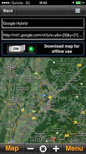
In africa I did navigate mostly with MotionX offline satellite hybrid images from Google/Bing together with the App Tracks 4 Africa

In Iceland I did use also MotionX with Openstreet Terrain Mapsources. The App MotionX allows also Trackrecording, to share tracks with others (Import/Export) and a lot more. A must have for us Overlanders.

Maps_With_Me__weltreise_navigation.jpg


In South America i did also start to use Maps.me - an App which allows to download mapsouces for offline usage. The App has also a Routing functionality which is pretty good there (and no alternatives available).


Each link above brings you to an short Review, which you should be able to read with Google translate.

die_besten_reise_apps_2016_reiseapp.jpg


I guess my summary about the most helpful travel apps may - could give you some suggestions too.


4x4tripping
 
Last edited:

shane4x4

Supporting Sponsor
As someone who knows little about off road nav technology, the sheer amount and diversity of content is a bit overwhelming - especially since providers usually consider full disclosure about capability and limits of their content a low priority: true story -
I'm at Overland Expo the other day talking to the Magellan rep. First, he' got nothing to sell me and he's showing me 2 tablets he borrowed from a friend. Really? He tells me all about his software and what it is/has/can do. So I open a section of map that I'm very familiar with to compare my knowledge with his map info. It's not even close. His level of info/content isn't at all what he described. Then the stammering and backstepping and excusing. But I'd have been really mad if I found that AFTER I bought his stuff.

So, perhaps I'd be better off soliciting your experience and opinions...

I'd like something as easy to use as a map/compass/ruler.
I'm a dedicated Apple user.
I use Garmin Basecamp for my hand held gps and like that level/ease of interface.

I think all I really need/want is
- access to maps with good detail i.e. topo info, dirt road/trail/2-tracks info, public/private land info - and basically the same level of info I would find on google earth
- offline map capability
- see my position on the map
- set waypoints before or during the trip
- capture routes as I travel them

I don't care about setting up tracks before hand.
I don't want something that requires a subscription - I'd rather pay more for something and be done with it...

So, are there offerings out there that can be that simple?
its a shame you didn't stop & see us at the Hema booth (unless you did). Full disclosure: I've been working with Hema Maps for the past year to help build their Explorer platform.

Other than a specific land-use layer (it's in the queue), I think the Hema Explorer app & cloud can get you pretty close:


- access to maps with good detail i.e. topo info, dirt road/trail/2-tracks info, public/private land info - and basically the same level of info I would find on google earth
--the layers included with the app cover topo, street, and terrain. All but satellite an be download for offline use.


- offline map capability
--yep. Multiple map layers with 1 tap, download all the maps for a specific track/trail at once.
- see my position on the map
--of course. North up & track up modes.


- set waypoints before or during the trip
--in the Hema Cloud, you can plan the entire adventure on your Mac prior to leaving. All routes, tracks, and waypoints will sync to your device.


- capture routes as I travel them
--three tap recording. Geotagged photos. Waypoints with notes, etc.

I could go on ;) but for all the details & links hit up:
http://hema.li/explorer
 
Last edited:

escadventure

Adventurer
I looked for the Hema booth and never saw it. I wish I did find it...

Thanks for everyone's suggestions ad info.
 

Forum statistics

Threads
185,783
Messages
2,878,184
Members
225,329
Latest member
FranklinDufresne
Top