You are using an out of date browser. It may not display this or other websites correctly.
You should upgrade or use an alternative browser.
You should upgrade or use an alternative browser.
Ideas for onboard wifi and gps.
- Thread starter sleeper00
- Start date
FellowTraveler
Explorer
Good/great deals on older toughbooks for mapping/wifi/gps
I've seen on e-bay and other sites good/great deals on surplus CF-29 toughbook (s) that will be perfect for mapping/wifi and gps.
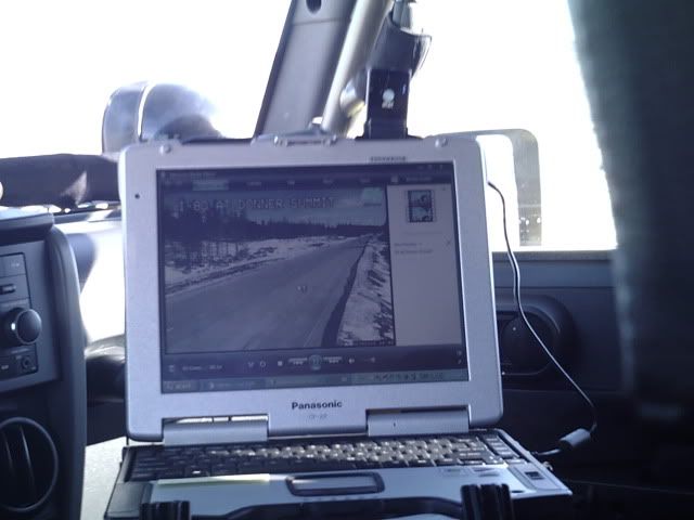
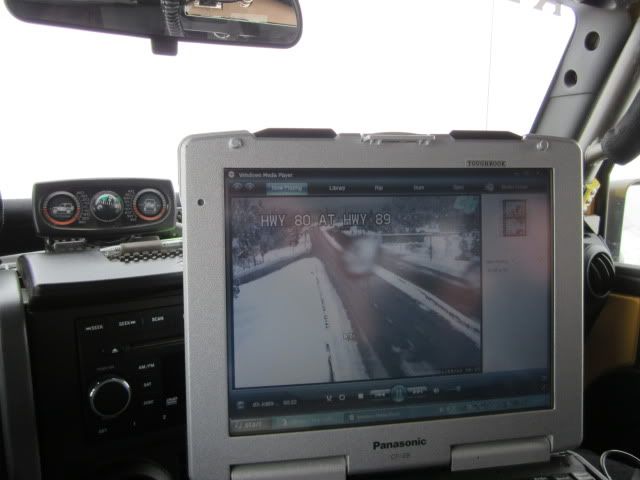
I purchased a series 5 CF-29 running XP nothing fancy but I can run OBD2 scanner, data logger and device controller, GPS mapping, and wifi isn't that bad.
I have the CF-53 too w/all the bells and whistles wifi/broadband/cellular do-dads.
I have had nothing but problems keeping a laptop running in my heavy burb until getting the toughbook (s)..
I've seen on e-bay and other sites good/great deals on surplus CF-29 toughbook (s) that will be perfect for mapping/wifi and gps.
I purchased a series 5 CF-29 running XP nothing fancy but I can run OBD2 scanner, data logger and device controller, GPS mapping, and wifi isn't that bad.
I have the CF-53 too w/all the bells and whistles wifi/broadband/cellular do-dads.
I have had nothing but problems keeping a laptop running in my heavy burb until getting the toughbook (s)..
theksmith
Explorer
+1 for Delorme topo as the main mapping software for on and off-road. it's not perfect, but is one of the better ones.
i tried using some of the pre-caching tools with google earth and found it too much of a hassle to bother. instead, i can just pay $30 a year to Delorme to get unlimited downloads of satellite and Arial photography.
i use a laptop with a docking station in the back of the rig and have a small touch-screen and keyboard up front. i don't have any solution for back-country data, but that's not something i really need. if in a town i can use my android phone as a mobile hot-spot for the laptop to connect through, or i just undock my laptop and go into a starbucks and use wifi while sitting at a table to plan out routes and download any new needed data. my main uses of the system are bigger screen maps than most GPS units, factory service manual in PDF and other random saved vehicle-related documents, and OBD-II diagnostics. i eventually hope to upgrade my HAM rig and then integrate the APRS features with the system too (using Overland Navigator). more info on my still evolving setup is here: http://www.mp3car.com/worklogs/1385...ition-vehicle-worklog-dockable-hp-laptop.html
oh and my screen has several inputs for cameras, currently i only have a rear-view installed, but plan to put front and rear axle cams to help me self-spot when i'm wheeling alone.
dwh
Tail-End Charlie
Not be repetitive, but what happens when out of cell range?
I'm doing this on BGAN, no wifi where I'm at.
Charlie
Charlie
Just to clarify: He was referring to using a GPS receiver - not a cellular receiver.
trailrunner
Observer
As I understand it your planning to use a cellphone to access some sort of 3G or 4G type wireless data network through which you can use the internet. Wi-Fi is a short range form of wireless communication that everyone uses in there homes. Most cell service providers (at least in Canada) sell USB dongles which allow you to use your computer to access the internet on there networks. Some have plugs for extended range antennas. That would reduce the need to tether to a cellphone. If you already have a cell-phone with a good data rate that you plan to connect through, you should check your computer to see if has bluetooth (another short range wireless system), or invest in a $20 bluetooth dongle. That would allow you to wirelessly tether your phone to your laptop (new smart phones all have bluetooth, and many older ones do as well) In my mind the less the cables the better. As you have said, a cell booster is necessary if you want to extend your range with your cell-phone.
coastsider
Adventurer
No one has mentioned the mighty iPad yet, I have used my GPS enabled iPad for many backcountry trips as my main navigation using the topo maps app (uses free USGS topo maps) and or the Motion X GPS HD app with flawless results No cell signal needed. I know the original poster wants wifi as well, but personally I go back country to get away from email and phone calls! Combined with an excellent RAM mount I also have 20GB of my favorite music and movies as well if I desire. Don't forget to always take 'real' maps and a compass as well though on any trip.