pnwadventurer
Observer
Originally posted at http://www.pnwadventures.com/adventures/burley_mountain_mt_st_helens_tour_2007/
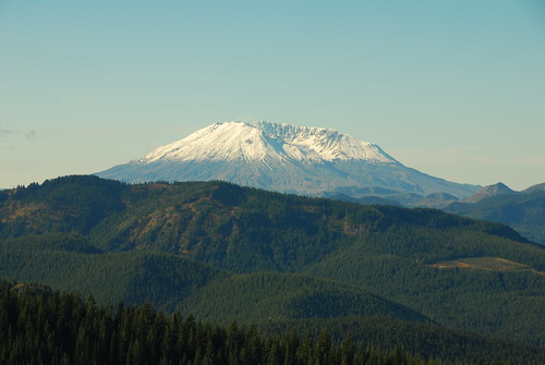
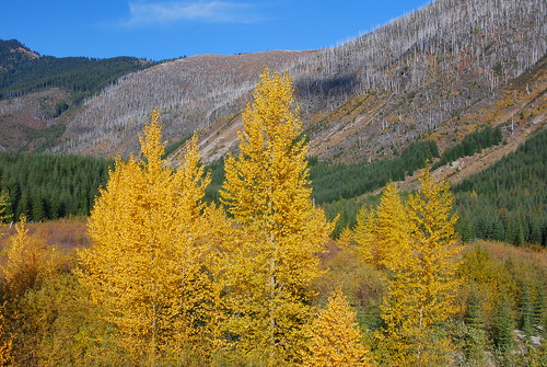
Each time I venture to the Gifford Pinchot National Forest in the South Cascades of Washington state, I am simply amazed at the beauty of the country. In this region, not only are you are surrounded by four major peaks of the Cascade Mountains (Mt. Rainier, Mt. St. Helens, Mt. Adams, and Mt. Hood), there is an extensive variety of terrain ranging from deep valleys and canyons to exposed buttes and cliffs, alpine meadows to old growth forests, and of course, the Mt. St. Helens blast zone. I could easily spend days or even weeks just exploring the region.
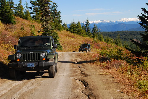
With that in mind, I decided to host a Backroad Drivers Northwest tour in the area just south of Randle, Washington. This region is an area which I am fairly familiar with having spent a lot of time hunting, camping and exploring with my father while growing up. The tour would follow one of my favorite routes in the area, Forest Road 77 from the Burley Mountain Lookout along the ridge past Pinto Rock and Mosquito Meadows. From Mosquito Meadows, we would would take FS 99 to the Windy Ridge Viewpoint at Mt. St. Helens and follow FS 26 back to Randle.
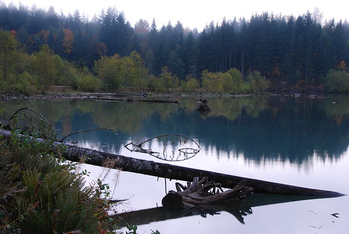
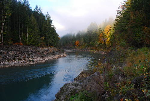
Since I got an early start that morning, I stopped by Lake Scanewa near Glenoma, Washington to take photos of the sunrise. Instead of a nice sunrise, I was met by fog and no spectacular sunrise. I figured that there wouldn't be that much traffic at the boat launch but I was wrong. Not only were there people launching their boats to go fishing, I was surprised to see hunters loading up in their boats and slowly cruising the far shoreline for deer (this day was the opening day of general buck season in the area). After what photos I could take, I drove down to the Cowlitz Falls Dam viewpoint and shot a few photos of the Cowlitz River below the dam.
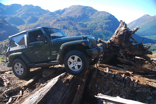
Once I was finished taking photos, I headed for the meeting place for the day's trip at the Mt Adams Cafe in Randle. When I arrived at the cafe, I was met by Rubicon Rich and his friend Michael from Vancouver, Washington (driving Rich's Jeep TJ Rubicon). We were shortly joined by Kelly from Eatonville, Washington (driving his Jeep JK Wrangler). After a hearty breakfast, we headed out from the cafe about 9:15.
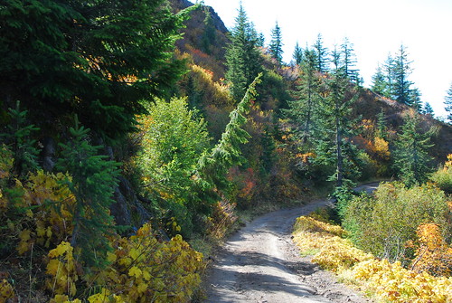
From US Highway 12 in Randle, we headed South on State Route 131 (also known as Woods Creek Road) until it turns into Forest Road 25. We passed by the swamps near Woods Creek, then followed the Cispus River past Iron Creek Campground and turned left (East) on FS-76 which follows the river. In about 3.5 miles, we turned right (South) on FS-77 and began the climb towards Burley Mountain.
FS 77 is a nice paved forest service road for the first 7.5 miles and then turns to a well maintained gravel road. After about 4.5 miles of gravel, we reached a 4-way intersection. To the right is FS 77, straight ahead is a dead end road and to the left (North) is FS 7605 which leads to the Burley Mountain Lookout. In less than 3 miles, there is a junction to the right with FS 7605-086 which leads to Burley Mountain (if you continue on FS 7605, it will take you back to FS 77 near the Cispus River).
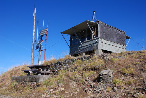
From the turn off on FS 7605-086, it is about a mile to the summit of the lookout. If the gate is not open there is a parking area and you can walk the rest of the way to the lookout. As usual, the gate was open and we continued on towards the summit. Just before the summit, there is an 180 degree switchback where there is room to park. There is another spot to park just before the lookout as well as room for two or three vehicles at the summit.
The Burley Mountain Lookout (elevation 5310 feet) is one of the few operational fire lookouts in the Gifford Pinchot National Forest. I'm not sure if they actually staff the lookout during the fire season, but the lookout building appeared to be well stocked and recently inhabited.
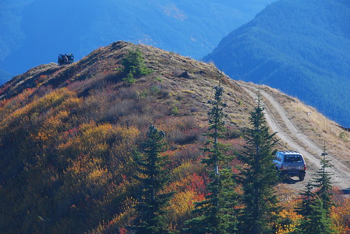
When we reached the summit of Burley Mountain, there was already a Ford F350 (which we would meet up later in the day) and a Jeep Wrangler parked there. Kelly drove his Jeep to the summit while I parked my Land Cruiser just downhill and Rich parked his Jeep at the last switchback.
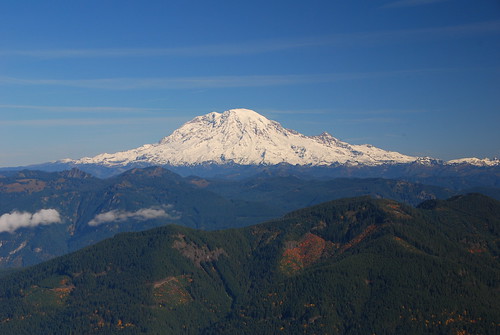
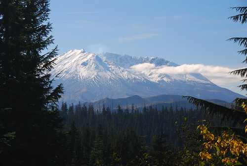
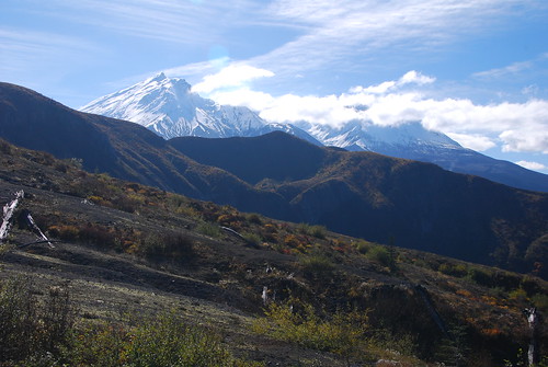
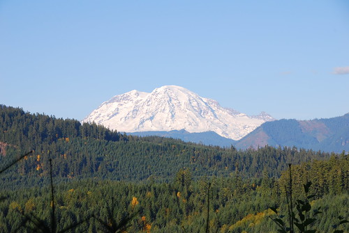
We were lucky today because the weather cooperated 99% for this trip. Clear blue skies allowed for excellent viewing and photo opportunities of Mt Rainier, Mt. St. Helens and Goat Rocks. Mt. Adams was also clear, however the angle of the sun prevented very good pictures. Mt. Hood in Oregon was not visible during our visit.
Continued...
Each time I venture to the Gifford Pinchot National Forest in the South Cascades of Washington state, I am simply amazed at the beauty of the country. In this region, not only are you are surrounded by four major peaks of the Cascade Mountains (Mt. Rainier, Mt. St. Helens, Mt. Adams, and Mt. Hood), there is an extensive variety of terrain ranging from deep valleys and canyons to exposed buttes and cliffs, alpine meadows to old growth forests, and of course, the Mt. St. Helens blast zone. I could easily spend days or even weeks just exploring the region.
With that in mind, I decided to host a Backroad Drivers Northwest tour in the area just south of Randle, Washington. This region is an area which I am fairly familiar with having spent a lot of time hunting, camping and exploring with my father while growing up. The tour would follow one of my favorite routes in the area, Forest Road 77 from the Burley Mountain Lookout along the ridge past Pinto Rock and Mosquito Meadows. From Mosquito Meadows, we would would take FS 99 to the Windy Ridge Viewpoint at Mt. St. Helens and follow FS 26 back to Randle.
Since I got an early start that morning, I stopped by Lake Scanewa near Glenoma, Washington to take photos of the sunrise. Instead of a nice sunrise, I was met by fog and no spectacular sunrise. I figured that there wouldn't be that much traffic at the boat launch but I was wrong. Not only were there people launching their boats to go fishing, I was surprised to see hunters loading up in their boats and slowly cruising the far shoreline for deer (this day was the opening day of general buck season in the area). After what photos I could take, I drove down to the Cowlitz Falls Dam viewpoint and shot a few photos of the Cowlitz River below the dam.
Once I was finished taking photos, I headed for the meeting place for the day's trip at the Mt Adams Cafe in Randle. When I arrived at the cafe, I was met by Rubicon Rich and his friend Michael from Vancouver, Washington (driving Rich's Jeep TJ Rubicon). We were shortly joined by Kelly from Eatonville, Washington (driving his Jeep JK Wrangler). After a hearty breakfast, we headed out from the cafe about 9:15.
From US Highway 12 in Randle, we headed South on State Route 131 (also known as Woods Creek Road) until it turns into Forest Road 25. We passed by the swamps near Woods Creek, then followed the Cispus River past Iron Creek Campground and turned left (East) on FS-76 which follows the river. In about 3.5 miles, we turned right (South) on FS-77 and began the climb towards Burley Mountain.
FS 77 is a nice paved forest service road for the first 7.5 miles and then turns to a well maintained gravel road. After about 4.5 miles of gravel, we reached a 4-way intersection. To the right is FS 77, straight ahead is a dead end road and to the left (North) is FS 7605 which leads to the Burley Mountain Lookout. In less than 3 miles, there is a junction to the right with FS 7605-086 which leads to Burley Mountain (if you continue on FS 7605, it will take you back to FS 77 near the Cispus River).
From the turn off on FS 7605-086, it is about a mile to the summit of the lookout. If the gate is not open there is a parking area and you can walk the rest of the way to the lookout. As usual, the gate was open and we continued on towards the summit. Just before the summit, there is an 180 degree switchback where there is room to park. There is another spot to park just before the lookout as well as room for two or three vehicles at the summit.
The Burley Mountain Lookout (elevation 5310 feet) is one of the few operational fire lookouts in the Gifford Pinchot National Forest. I'm not sure if they actually staff the lookout during the fire season, but the lookout building appeared to be well stocked and recently inhabited.
When we reached the summit of Burley Mountain, there was already a Ford F350 (which we would meet up later in the day) and a Jeep Wrangler parked there. Kelly drove his Jeep to the summit while I parked my Land Cruiser just downhill and Rich parked his Jeep at the last switchback.
We were lucky today because the weather cooperated 99% for this trip. Clear blue skies allowed for excellent viewing and photo opportunities of Mt Rainier, Mt. St. Helens and Goat Rocks. Mt. Adams was also clear, however the angle of the sun prevented very good pictures. Mt. Hood in Oregon was not visible during our visit.
Continued...
")